You are here: Home > Network List > TD - TransAlta Monitoring Network Stations List
> Station TD009 Z > Earthquake Result Viewer
TD009 Z - Earthquake Result Viewer
| Earthquake location: |
Southern East Pacific Rise |
| Earthquake latitude/longitude: |
-33.1/-109.4 |
| Earthquake time(UTC): |
2021/05/19 (139) 00:42:19 GMT |
| Earthquake Depth: |
10 km |
| Earthquake Magnitude: |
6.7 mww |
| Earthquake Catalog/Contributor: |
NEIC PDE/us |
|
| Network: |
TD TransAlta Monitoring Network |
| Station: |
TD009 Z |
| Lat/Lon: |
52.32 N/116.32 W |
| Elevation: |
1335 m |
|
| Distance: |
85.2 deg |
| Az: |
355.739 deg |
| Baz: |
174.165 deg |
| Ray Param: |
0.04490917 |
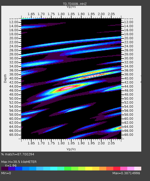
| Estimated Moho Depth: |
38.5 km |
| Estimated Crust Vp/Vs: |
1.96 |
| Assumed Crust Vp: |
6.142 km/s |
| Estimated Crust Vs: |
3.134 km/s |
| Estimated Crust Poisson's Ratio: |
0.32 |
|
| Radial Match: |
87.700294 % |
| Radial Bump: |
400 |
| Transverse Match: |
83.875435 % |
| Transverse Bump: |
400 |
| SOD ConfigId: |
24890451 |
| Insert Time: |
2021-06-02 18:21:08.415 +0000 |
| GWidth: |
2.5 |
| Max Bumps: |
400 |
| Tol: |
0.001 |
|

Signal To Noise
| Channel | StoN | STA | LTA |
| TD:TD009: :HHZ:20210519T00:54:24.880017Z | 5.7781777 | 5.568313E-7 | 9.636798E-8 |
| TD:TD009: :HH1:20210519T00:54:24.880017Z | 2.2315938 | 2.6044552E-7 | 1.167083E-7 |
| TD:TD009: :HH2:20210519T00:54:24.880017Z | 2.2871408 | 2.078919E-7 | 9.089598E-8 |
| Arrivals |
| Ps | 6.1 SECOND |
| PpPs | 18 SECOND |
| PsPs/PpSs | 24 SECOND |


