You are here: Home > Network List > TX - Texas Seismological Network Stations List
> Station EF02 Christine > Earthquake Result Viewer
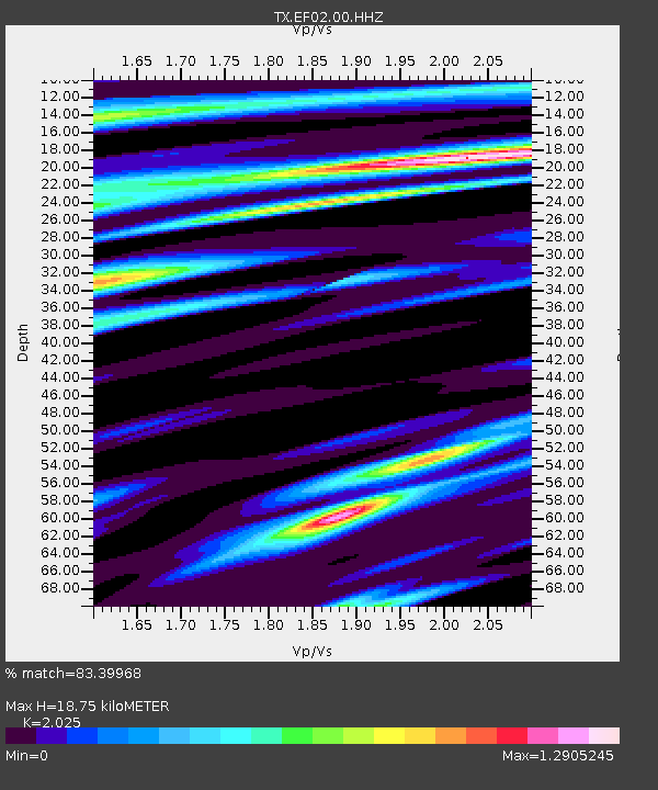
EF02 Christine - Earthquake Result Viewer
| Earthquake location: |
Southern East Pacific Rise |
| Earthquake latitude/longitude: |
-33.1/-109.4 |
| Earthquake time(UTC): |
2021/05/19 (139) 00:42:19 GMT |
| Earthquake Depth: |
10 km |
| Earthquake Magnitude: |
6.7 mww |
| Earthquake Catalog/Contributor: |
NEIC PDE/us |
|
| Network: |
TX Texas Seismological Network |
| Station: |
EF02 Christine |
| Lat/Lon: |
28.78 N/98.53 W |
| Elevation: |
96 m |
|
| Distance: |
62.4 deg |
| Az: |
10.764 deg |
| Baz: |
190.291 deg |
| Ray Param: |
0.060280852 |
| Estimated Moho Depth: |
18.75 km |
| Estimated Crust Vp/Vs: |
2.03 |
| Assumed Crust Vp: |
6.347 km/s |
| Estimated Crust Vs: |
3.134 km/s |
| Estimated Crust Poisson's Ratio: |
0.34 |
|
| Radial Match: |
83.39968 % |
| Radial Bump: |
400 |
| Transverse Match: |
64.97344 % |
| Transverse Bump: |
400 |
| SOD ConfigId: |
24890451 |
| Insert Time: |
2021-06-02 18:21:23.301 +0000 |
| GWidth: |
2.5 |
| Max Bumps: |
400 |
| Tol: |
0.001 |
|

Signal To Noise
| Channel | StoN | STA | LTA |
| TX:EF02:00:HHZ:20210519T00:52:11.200024Z | 2.8758032 | 6.466727E-7 | 2.2486681E-7 |
| TX:EF02:00:HHN:20210519T00:52:11.200024Z | 1.3832594 | 2.7011612E-7 | 1.9527509E-7 |
| TX:EF02:00:HHE:20210519T00:52:11.200024Z | 1.0455657 | 3.471159E-7 | 3.319886E-7 |
| Arrivals |
| Ps | 3.1 SECOND |
| PpPs | 8.6 SECOND |
| PsPs/PpSs | 12 SECOND |


