You are here: Home > Network List > TX - Texas Seismological Network Stations List
> Station PB10 Southeast of Toyah > Earthquake Result Viewer
PB10 Southeast of Toyah - Earthquake Result Viewer
| Earthquake location: |
Southern East Pacific Rise |
| Earthquake latitude/longitude: |
-33.1/-109.4 |
| Earthquake time(UTC): |
2021/05/19 (139) 00:42:19 GMT |
| Earthquake Depth: |
10 km |
| Earthquake Magnitude: |
6.7 mww |
| Earthquake Catalog/Contributor: |
NEIC PDE/us |
|
| Network: |
TX Texas Seismological Network |
| Station: |
PB10 Southeast of Toyah |
| Lat/Lon: |
31.28 N/103.75 W |
| Elevation: |
858 m |
|
| Distance: |
64.2 deg |
| Az: |
5.361 deg |
| Baz: |
185.258 deg |
| Ray Param: |
0.059060626 |
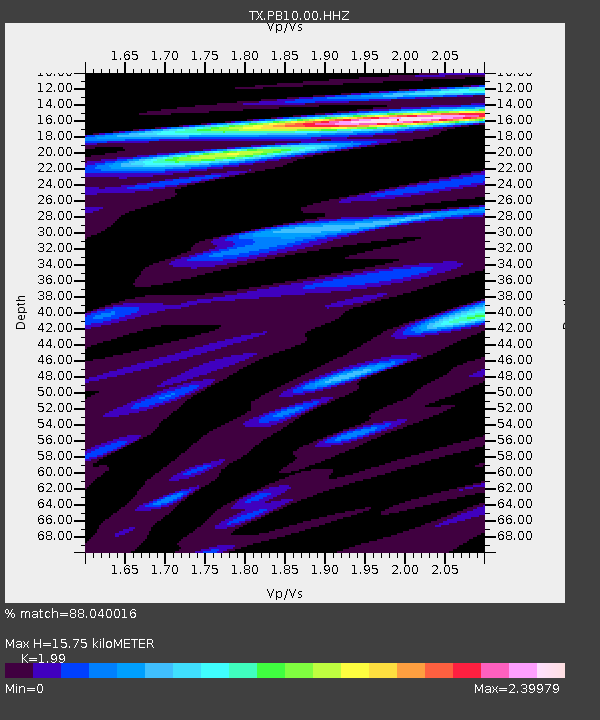
| Estimated Moho Depth: |
15.75 km |
| Estimated Crust Vp/Vs: |
1.99 |
| Assumed Crust Vp: |
6.121 km/s |
| Estimated Crust Vs: |
3.076 km/s |
| Estimated Crust Poisson's Ratio: |
0.33 |
|
| Radial Match: |
88.040016 % |
| Radial Bump: |
400 |
| Transverse Match: |
74.368385 % |
| Transverse Bump: |
400 |
| SOD ConfigId: |
24890451 |
| Insert Time: |
2021-06-02 18:21:55.484 +0000 |
| GWidth: |
2.5 |
| Max Bumps: |
400 |
| Tol: |
0.001 |
|

Signal To Noise
| Channel | StoN | STA | LTA |
| TX:PB10:00:HHZ:20210519T00:52:23.52998Z | 2.546825 | 4.2284984E-7 | 1.6603019E-7 |
| TX:PB10:00:HH1:20210519T00:52:23.52998Z | 2.4296312 | 2.8114488E-7 | 1.1571504E-7 |
| TX:PB10:00:HH2:20210519T00:52:23.52998Z | 0.8533679 | 1.7519471E-7 | 2.05298E-7 |
| Arrivals |
| Ps | 2.6 SECOND |
| PpPs | 7.4 SECOND |
| PsPs/PpSs | 10 SECOND |


