You are here: Home > Network List > TX - Texas Seismological Network Stations List
> Station SN03 Snyder 3 > Earthquake Result Viewer
SN03 Snyder 3 - Earthquake Result Viewer
| Earthquake location: |
Southern East Pacific Rise |
| Earthquake latitude/longitude: |
-33.1/-109.4 |
| Earthquake time(UTC): |
2021/05/19 (139) 00:42:19 GMT |
| Earthquake Depth: |
10 km |
| Earthquake Magnitude: |
6.7 mww |
| Earthquake Catalog/Contributor: |
NEIC PDE/us |
|
| Network: |
TX Texas Seismological Network |
| Station: |
SN03 Snyder 3 |
| Lat/Lon: |
32.92 N/100.94 W |
| Elevation: |
744 m |
|
| Distance: |
66.1 deg |
| Az: |
7.771 deg |
| Baz: |
187.758 deg |
| Ray Param: |
0.057828993 |
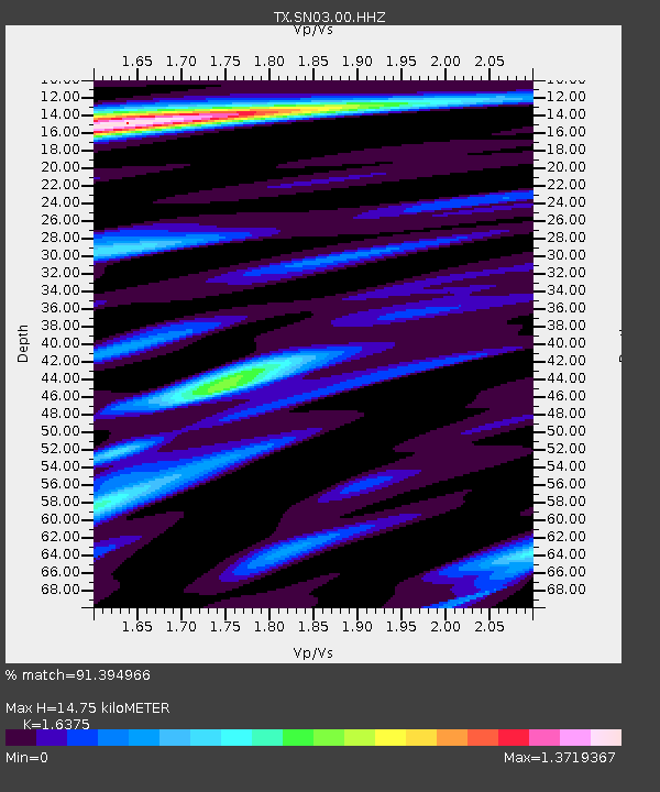
| Estimated Moho Depth: |
14.75 km |
| Estimated Crust Vp/Vs: |
1.64 |
| Assumed Crust Vp: |
6.426 km/s |
| Estimated Crust Vs: |
3.924 km/s |
| Estimated Crust Poisson's Ratio: |
0.20 |
|
| Radial Match: |
91.394966 % |
| Radial Bump: |
400 |
| Transverse Match: |
71.50413 % |
| Transverse Bump: |
400 |
| SOD ConfigId: |
24890451 |
| Insert Time: |
2021-06-02 18:22:17.653 +0000 |
| GWidth: |
2.5 |
| Max Bumps: |
400 |
| Tol: |
0.001 |
|
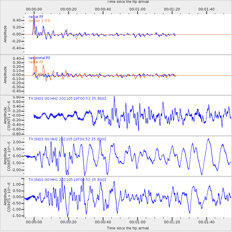
Signal To Noise
| Channel | StoN | STA | LTA |
| TX:SN03:00:HHZ:20210519T00:52:35.800Z | 5.2373786 | 5.6251133E-7 | 1.0740321E-7 |
| TX:SN03:00:HH1:20210519T00:52:35.800Z | 3.5077102 | 1.9375314E-7 | 5.5236356E-8 |
| TX:SN03:00:HH2:20210519T00:52:35.800Z | 2.439601 | 1.8992874E-7 | 7.7852384E-8 |
| Arrivals |
| Ps | 1.5 SECOND |
| PpPs | 5.8 SECOND |
| PsPs/PpSs | 7.3 SECOND |


