You are here: Home > Network List > US - United States National Seismic Network Stations List
> Station HAWA Hanford, Washington, USA > Earthquake Result Viewer
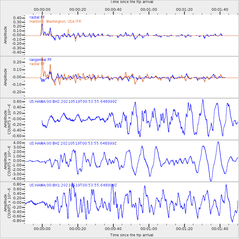
HAWA Hanford, Washington, USA - Earthquake Result Viewer
*The percent match for this event was below the threshold and hence no stack was calculated.
| Earthquake location: |
Southern East Pacific Rise |
| Earthquake latitude/longitude: |
-33.1/-109.4 |
| Earthquake time(UTC): |
2021/05/19 (139) 00:42:19 GMT |
| Earthquake Depth: |
10 km |
| Earthquake Magnitude: |
6.7 mww |
| Earthquake Catalog/Contributor: |
NEIC PDE/us |
|
| Network: |
US United States National Seismic Network |
| Station: |
HAWA Hanford, Washington, USA |
| Lat/Lon: |
46.39 N/119.53 W |
| Elevation: |
364 m |
|
| Distance: |
79.6 deg |
| Az: |
352.885 deg |
| Baz: |
171.357 deg |
| Ray Param: |
$rayparam |
*The percent match for this event was below the threshold and hence was not used in the summary stack. |
|
| Radial Match: |
79.118256 % |
| Radial Bump: |
400 |
| Transverse Match: |
88.32022 % |
| Transverse Bump: |
400 |
| SOD ConfigId: |
24890451 |
| Insert Time: |
2021-06-02 18:23:18.420 +0000 |
| GWidth: |
2.5 |
| Max Bumps: |
400 |
| Tol: |
0.001 |
|
Signal To Noise
| Channel | StoN | STA | LTA |
| US:HAWA:00:BHZ:20210519T00:53:55.648999Z | 2.8322072 | 2.2673379E-7 | 8.005551E-8 |
| US:HAWA:00:BH1:20210519T00:53:55.648999Z | 1.4151796 | 9.020418E-8 | 6.374045E-8 |
| US:HAWA:00:BH2:20210519T00:53:55.648999Z | 0.50035554 | 5.555708E-8 | 1.1103521E-7 |
| Arrivals |
| Ps | |
| PpPs | |
| PsPs/PpSs | |


