You are here: Home > Network List > US - United States National Seismic Network Stations List
> Station OGNE Ogallala, Nebraska, USA > Earthquake Result Viewer
OGNE Ogallala, Nebraska, USA - Earthquake Result Viewer

| Earthquake location: |
Southern East Pacific Rise |
| Earthquake latitude/longitude: |
-33.1/-109.4 |
| Earthquake time(UTC): |
2021/05/19 (139) 00:42:19 GMT |
| Earthquake Depth: |
10 km |
| Earthquake Magnitude: |
6.7 mww |
| Earthquake Catalog/Contributor: |
NEIC PDE/us |
|
| Network: |
US United States National Seismic Network |
| Station: |
OGNE Ogallala, Nebraska, USA |
| Lat/Lon: |
40.95 N/102.03 W |
| Elevation: |
1054 m |
|
| Distance: |
74.0 deg |
| Az: |
5.796 deg |
| Baz: |
186.428 deg |
| Ray Param: |
0.05266972 |
| Estimated Moho Depth: |
15.0 km |
| Estimated Crust Vp/Vs: |
1.68 |
| Assumed Crust Vp: |
6.483 km/s |
| Estimated Crust Vs: |
3.864 km/s |
| Estimated Crust Poisson's Ratio: |
0.22 |
|
| Radial Match: |
93.008644 % |
| Radial Bump: |
375 |
| Transverse Match: |
85.01369 % |
| Transverse Bump: |
400 |
| SOD ConfigId: |
24890451 |
| Insert Time: |
2021-06-02 18:23:43.390 +0000 |
| GWidth: |
2.5 |
| Max Bumps: |
400 |
| Tol: |
0.001 |
|
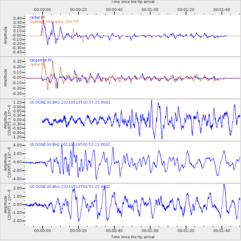
Signal To Noise
| Channel | StoN | STA | LTA |
| US:OGNE:00:BHZ:20210519T00:53:23.800Z | 3.6112041 | 4.3038608E-7 | 1.1918077E-7 |
| US:OGNE:00:BH1:20210519T00:53:23.800Z | 1.3482708 | 1.9825947E-7 | 1.4704723E-7 |
| US:OGNE:00:BH2:20210519T00:53:23.800Z | 1.006817 | 1.680409E-7 | 1.6690312E-7 |
| Arrivals |
| Ps | 1.6 SECOND |
| PpPs | 6.0 SECOND |
| PsPs/PpSs | 7.6 SECOND |


