You are here: Home > Network List > UU - University of Utah Regional Network Stations List
> Station HMU Henry Mountain, UT, USA > Earthquake Result Viewer
HMU Henry Mountain, UT, USA - Earthquake Result Viewer
| Earthquake location: |
Southern East Pacific Rise |
| Earthquake latitude/longitude: |
-33.1/-109.4 |
| Earthquake time(UTC): |
2021/05/19 (139) 00:42:19 GMT |
| Earthquake Depth: |
10 km |
| Earthquake Magnitude: |
6.7 mww |
| Earthquake Catalog/Contributor: |
NEIC PDE/us |
|
| Network: |
UU University of Utah Regional Network |
| Station: |
HMU Henry Mountain, UT, USA |
| Lat/Lon: |
37.94 N/110.74 W |
| Elevation: |
2430 m |
|
| Distance: |
70.7 deg |
| Az: |
358.871 deg |
| Baz: |
178.801 deg |
| Ray Param: |
0.054854643 |
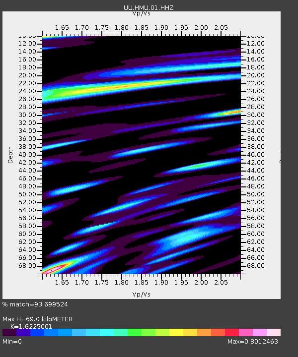
| Estimated Moho Depth: |
69.0 km |
| Estimated Crust Vp/Vs: |
1.62 |
| Assumed Crust Vp: |
6.247 km/s |
| Estimated Crust Vs: |
3.85 km/s |
| Estimated Crust Poisson's Ratio: |
0.19 |
|
| Radial Match: |
93.699524 % |
| Radial Bump: |
400 |
| Transverse Match: |
79.65935 % |
| Transverse Bump: |
400 |
| SOD ConfigId: |
24890451 |
| Insert Time: |
2021-06-02 18:24:11.993 +0000 |
| GWidth: |
2.5 |
| Max Bumps: |
400 |
| Tol: |
0.001 |
|

Signal To Noise
| Channel | StoN | STA | LTA |
| UU:HMU:01:HHZ:20210519T00:53:04.097973Z | 2.6824305 | 8.890243E-9 | 3.3142493E-9 |
| UU:HMU:01:HHN:20210519T00:53:04.097973Z | 1.8635918 | 6.096528E-9 | 3.2713858E-9 |
| UU:HMU:01:HHE:20210519T00:53:04.097973Z | 1.5171847 | 5.772466E-9 | 3.804722E-9 |
| Arrivals |
| Ps | 7.1 SECOND |
| PpPs | 28 SECOND |
| PsPs/PpSs | 35 SECOND |


