You are here: Home > Network List > KZ - Kazakhstan Network Stations List
> Station ABKAR Akbulak array,AB31, Kazakhstan > Earthquake Result Viewer
ABKAR Akbulak array,AB31, Kazakhstan - Earthquake Result Viewer
| Earthquake location: |
Near East Coast Of Honshu, Japan |
| Earthquake latitude/longitude: |
40.2/142.2 |
| Earthquake time(UTC): |
2009/02/15 (046) 09:24:31 GMT |
| Earthquake Depth: |
33 km |
| Earthquake Magnitude: |
6.1 MB, 5.5 MS, 5.7 MW, 5.7 MW |
| Earthquake Catalog/Contributor: |
WHDF/NEIC |
|
| Network: |
KZ Kazakhstan Network |
| Station: |
ABKAR Akbulak array,AB31, Kazakhstan |
| Lat/Lon: |
49.26 N/59.94 E |
| Elevation: |
362 m |
|
| Distance: |
56.4 deg |
| Az: |
308.785 deg |
| Baz: |
65.605 deg |
| Ray Param: |
0.06410648 |
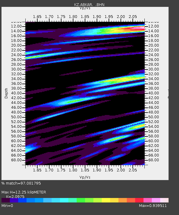
| Estimated Moho Depth: |
12.25 km |
| Estimated Crust Vp/Vs: |
2.10 |
| Assumed Crust Vp: |
6.35 km/s |
| Estimated Crust Vs: |
3.027 km/s |
| Estimated Crust Poisson's Ratio: |
0.35 |
|
| Radial Match: |
97.081795 % |
| Radial Bump: |
400 |
| Transverse Match: |
90.95992 % |
| Transverse Bump: |
400 |
| SOD ConfigId: |
2658 |
| Insert Time: |
2010-03-09 08:30:34.025 +0000 |
| GWidth: |
2.5 |
| Max Bumps: |
400 |
| Tol: |
0.001 |
|

Signal To Noise
| Channel | StoN | STA | LTA |
| KZ:ABKAR: :BHN:20090215T09:33:39.173999Z | 62.12392 | 6.711265E-6 | 1.08030285E-7 |
| KZ:ABKAR: :BHE:20090215T09:33:39.173999Z | 21.703005 | 1.6212413E-6 | 7.4701234E-8 |
| KZ:ABKAR: :BHZ:20090215T09:33:39.173999Z | 42.74339 | 3.969852E-6 | 9.28764E-8 |
| Arrivals |
| Ps | 2.2 SECOND |
| PpPs | 5.7 SECOND |
| PsPs/PpSs | 7.9 SECOND |


