You are here: Home > Network List > NN - Western Great Basin/Eastern Sierra Nevada Stations List
> Station ZPR Zephyr Cove, Lake Tahoe, Nevada > Earthquake Result Viewer
ZPR Zephyr Cove, Lake Tahoe, Nevada - Earthquake Result Viewer
| Earthquake location: |
Southern East Pacific Rise |
| Earthquake latitude/longitude: |
-36.8/-110.4 |
| Earthquake time(UTC): |
2021/05/19 (139) 17:54:36 GMT |
| Earthquake Depth: |
10 km |
| Earthquake Magnitude: |
5.1 mb |
| Earthquake Catalog/Contributor: |
NEIC PDE/us |
|
| Network: |
NN Western Great Basin/Eastern Sierra Nevada |
| Station: |
ZPR Zephyr Cove, Lake Tahoe, Nevada |
| Lat/Lon: |
39.01 N/119.94 W |
| Elevation: |
2001 m |
|
| Distance: |
75.9 deg |
| Az: |
352.328 deg |
| Baz: |
172.089 deg |
| Ray Param: |
0.051353503 |
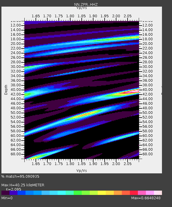
| Estimated Moho Depth: |
40.25 km |
| Estimated Crust Vp/Vs: |
2.10 |
| Assumed Crust Vp: |
6.279 km/s |
| Estimated Crust Vs: |
2.997 km/s |
| Estimated Crust Poisson's Ratio: |
0.35 |
|
| Radial Match: |
95.090935 % |
| Radial Bump: |
246 |
| Transverse Match: |
52.687492 % |
| Transverse Bump: |
400 |
| SOD ConfigId: |
24890451 |
| Insert Time: |
2021-06-02 18:40:02.592 +0000 |
| GWidth: |
2.5 |
| Max Bumps: |
400 |
| Tol: |
0.001 |
|

Signal To Noise
| Channel | StoN | STA | LTA |
| NN:ZPR: :HHZ:20210519T18:05:51.528009Z | 2.171178 | 1.6978076E-7 | 7.819753E-8 |
| NN:ZPR: :HHN:20210519T18:05:51.528009Z | 1.4453062 | 2.1200158E-7 | 1.4668281E-7 |
| NN:ZPR: :HHE:20210519T18:05:51.528009Z | 1.0269082 | 1.3002212E-7 | 1.2661512E-7 |
| Arrivals |
| Ps | 7.2 SECOND |
| PpPs | 19 SECOND |
| PsPs/PpSs | 27 SECOND |


