You are here: Home > Network List > US - United States National Seismic Network Stations List
> Station MIAR Mount Ida, Arkansas, USA > Earthquake Result Viewer
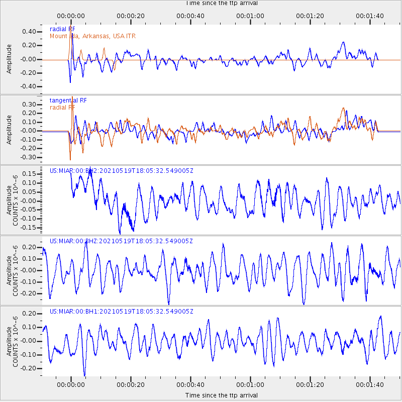
MIAR Mount Ida, Arkansas, USA - Earthquake Result Viewer
*The percent match for this event was below the threshold and hence no stack was calculated.
| Earthquake location: |
Southern East Pacific Rise |
| Earthquake latitude/longitude: |
-36.8/-110.4 |
| Earthquake time(UTC): |
2021/05/19 (139) 17:54:36 GMT |
| Earthquake Depth: |
10 km |
| Earthquake Magnitude: |
5.1 mb |
| Earthquake Catalog/Contributor: |
NEIC PDE/us |
|
| Network: |
US United States National Seismic Network |
| Station: |
MIAR Mount Ida, Arkansas, USA |
| Lat/Lon: |
34.55 N/93.58 W |
| Elevation: |
207 m |
|
| Distance: |
72.6 deg |
| Az: |
14.469 deg |
| Baz: |
194.069 deg |
| Ray Param: |
$rayparam |
*The percent match for this event was below the threshold and hence was not used in the summary stack. |
|
| Radial Match: |
47.54712 % |
| Radial Bump: |
400 |
| Transverse Match: |
46.562042 % |
| Transverse Bump: |
400 |
| SOD ConfigId: |
24890451 |
| Insert Time: |
2021-06-02 18:45:23.741 +0000 |
| GWidth: |
2.5 |
| Max Bumps: |
400 |
| Tol: |
0.001 |
|
Signal To Noise
| Channel | StoN | STA | LTA |
| US:MIAR:00:BHZ:20210519T18:05:32.549005Z | 1.1527138 | 1.09668555E-7 | 9.513945E-8 |
| US:MIAR:00:BH1:20210519T18:05:32.549005Z | 1.2839667 | 1.3233637E-7 | 1.0306839E-7 |
| US:MIAR:00:BH2:20210519T18:05:32.549005Z | 0.3187145 | 2.8350637E-8 | 8.895308E-8 |
| Arrivals |
| Ps | |
| PpPs | |
| PsPs/PpSs | |


