You are here: Home > Network List > US - United States National Seismic Network Stations List
> Station NEW Newport, Washington, USA > Earthquake Result Viewer
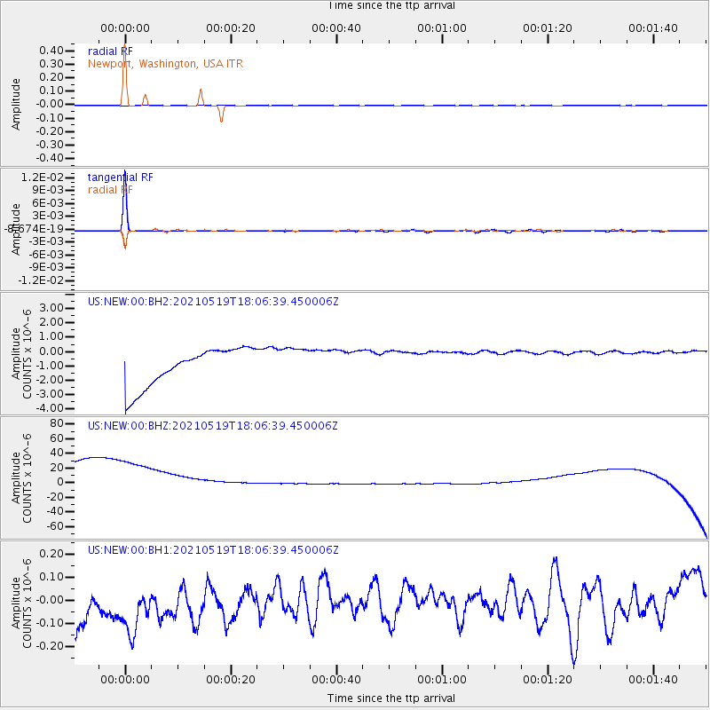
NEW Newport, Washington, USA - Earthquake Result Viewer
*The percent match for this event was below the threshold and hence no stack was calculated.
| Earthquake location: |
Southern East Pacific Rise |
| Earthquake latitude/longitude: |
-36.8/-110.4 |
| Earthquake time(UTC): |
2021/05/19 (139) 17:54:36 GMT |
| Earthquake Depth: |
10 km |
| Earthquake Magnitude: |
5.1 mb |
| Earthquake Catalog/Contributor: |
NEIC PDE/us |
|
| Network: |
US United States National Seismic Network |
| Station: |
NEW Newport, Washington, USA |
| Lat/Lon: |
48.26 N/117.12 W |
| Elevation: |
760 m |
|
| Distance: |
84.9 deg |
| Az: |
355.477 deg |
| Baz: |
174.561 deg |
| Ray Param: |
$rayparam |
*The percent match for this event was below the threshold and hence was not used in the summary stack. |
|
| Radial Match: |
95.87943 % |
| Radial Bump: |
260 |
| Transverse Match: |
99.116974 % |
| Transverse Bump: |
84 |
| SOD ConfigId: |
24890451 |
| Insert Time: |
2021-06-02 18:45:26.180 +0000 |
| GWidth: |
2.5 |
| Max Bumps: |
400 |
| Tol: |
0.001 |
|
Signal To Noise
| Channel | StoN | STA | LTA |
| US:NEW:00:BHZ:20210519T18:06:39.450006Z | 0.89576524 | 1.244186E-4 | 1.3889643E-4 |
| US:NEW:00:BH1:20210519T18:06:39.450006Z | 0.95503956 | 2.9541724E-7 | 3.093246E-7 |
| US:NEW:00:BH2:20210519T18:06:39.450006Z | 0.9087666 | 1.197188E-6 | 1.3173767E-6 |
| Arrivals |
| Ps | |
| PpPs | |
| PsPs/PpSs | |


