You are here: Home > Network List > UW - Pacific Northwest Regional Seismic Network Stations List
> Station HOOD Mt Hood Meadows, OR CREST BB SMO > Earthquake Result Viewer
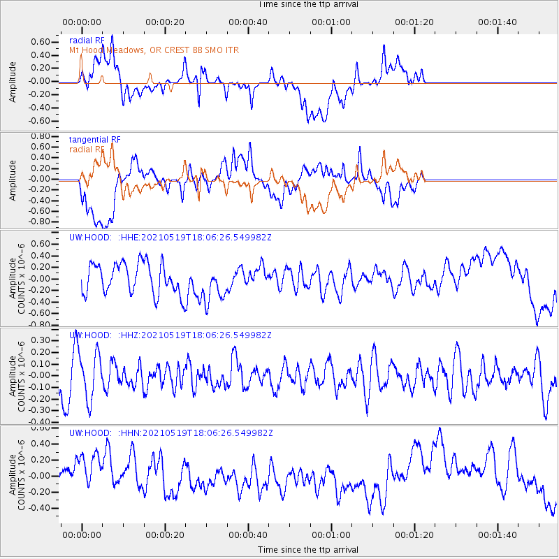
HOOD Mt Hood Meadows, OR CREST BB SMO - Earthquake Result Viewer
*The percent match for this event was below the threshold and hence no stack was calculated.
| Earthquake location: |
Southern East Pacific Rise |
| Earthquake latitude/longitude: |
-36.8/-110.4 |
| Earthquake time(UTC): |
2021/05/19 (139) 17:54:36 GMT |
| Earthquake Depth: |
10 km |
| Earthquake Magnitude: |
5.1 mb |
| Earthquake Catalog/Contributor: |
NEIC PDE/us |
|
| Network: |
UW Pacific Northwest Regional Seismic Network |
| Station: |
HOOD Mt Hood Meadows, OR CREST BB SMO |
| Lat/Lon: |
45.32 N/121.65 W |
| Elevation: |
1520 m |
|
| Distance: |
82.3 deg |
| Az: |
351.993 deg |
| Baz: |
170.877 deg |
| Ray Param: |
$rayparam |
*The percent match for this event was below the threshold and hence was not used in the summary stack. |
|
| Radial Match: |
26.146675 % |
| Radial Bump: |
400 |
| Transverse Match: |
19.928091 % |
| Transverse Bump: |
400 |
| SOD ConfigId: |
24890451 |
| Insert Time: |
2021-06-02 18:46:08.689 +0000 |
| GWidth: |
2.5 |
| Max Bumps: |
400 |
| Tol: |
0.001 |
|
Signal To Noise
| Channel | StoN | STA | LTA |
| UW:HOOD: :HHZ:20210519T18:06:26.549982Z | 1.3252237 | 2.0247776E-7 | 1.527876E-7 |
| UW:HOOD: :HHN:20210519T18:06:26.549982Z | 1.8539348 | 2.730727E-7 | 1.4729358E-7 |
| UW:HOOD: :HHE:20210519T18:06:26.549982Z | 1.2080472 | 3.2015492E-7 | 2.6501857E-7 |
| Arrivals |
| Ps | |
| PpPs | |
| PsPs/PpSs | |


