You are here: Home > Network List > IC - New China Digital Seismograph Network Stations List
> Station KMI Kunming, Yunnan Province, China > Earthquake Result Viewer
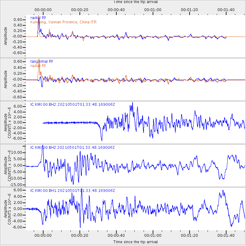
KMI Kunming, Yunnan Province, China - Earthquake Result Viewer
*The percent match for this event was below the threshold and hence no stack was calculated.
| Earthquake location: |
Near East Coast Of Honshu, Japan |
| Earthquake latitude/longitude: |
38.1/141.8 |
| Earthquake time(UTC): |
2021/05/01 (121) 01:27:30 GMT |
| Earthquake Depth: |
56 km |
| Earthquake Magnitude: |
6.6 Mi |
| Earthquake Catalog/Contributor: |
NEIC PDE/at |
|
| Network: |
IC New China Digital Seismograph Network |
| Station: |
KMI Kunming, Yunnan Province, China |
| Lat/Lon: |
25.12 N/102.74 E |
| Elevation: |
1975 m |
|
| Distance: |
35.4 deg |
| Az: |
260.129 deg |
| Baz: |
59.031 deg |
| Ray Param: |
$rayparam |
*The percent match for this event was below the threshold and hence was not used in the summary stack. |
|
| Radial Match: |
91.14946 % |
| Radial Bump: |
400 |
| Transverse Match: |
82.824066 % |
| Transverse Bump: |
400 |
| SOD ConfigId: |
25028951 |
| Insert Time: |
2021-06-02 22:51:21.467 +0000 |
| GWidth: |
2.5 |
| Max Bumps: |
400 |
| Tol: |
0.001 |
|
Signal To Noise
| Channel | StoN | STA | LTA |
| IC:KMI:00:BHZ:20210501T01:33:48.169006Z | 71.70613 | 6.8140876E-6 | 9.5027964E-8 |
| IC:KMI:00:BH1:20210501T01:33:48.169006Z | 20.446987 | 2.5197812E-6 | 1.2323484E-7 |
| IC:KMI:00:BH2:20210501T01:33:48.169006Z | 20.911833 | 2.8064674E-6 | 1.3420475E-7 |
| Arrivals |
| Ps | |
| PpPs | |
| PsPs/PpSs | |


