You are here: Home > Network List > IC - New China Digital Seismograph Network Stations List
> Station WMQ Urumqi, Xinjiang Province, China > Earthquake Result Viewer
WMQ Urumqi, Xinjiang Province, China - Earthquake Result Viewer

| Earthquake location: |
Southern Sumatra, Indonesia |
| Earthquake latitude/longitude: |
-2.3/99.8 |
| Earthquake time(UTC): |
2021/05/02 (122) 17:46:41 GMT |
| Earthquake Depth: |
21 km |
| Earthquake Magnitude: |
5.5 mww |
| Earthquake Catalog/Contributor: |
NEIC PDE/us |
|
| Network: |
IC New China Digital Seismograph Network |
| Station: |
WMQ Urumqi, Xinjiang Province, China |
| Lat/Lon: |
43.82 N/87.69 E |
| Elevation: |
903 m |
|
| Distance: |
47.2 deg |
| Az: |
348.042 deg |
| Baz: |
163.38 deg |
| Ray Param: |
0.07013748 |
| Estimated Moho Depth: |
60.75 km |
| Estimated Crust Vp/Vs: |
1.69 |
| Assumed Crust Vp: |
6.242 km/s |
| Estimated Crust Vs: |
3.693 km/s |
| Estimated Crust Poisson's Ratio: |
0.23 |
|
| Radial Match: |
94.62296 % |
| Radial Bump: |
400 |
| Transverse Match: |
88.31199 % |
| Transverse Bump: |
400 |
| SOD ConfigId: |
25028951 |
| Insert Time: |
2021-06-02 22:58:23.319 +0000 |
| GWidth: |
2.5 |
| Max Bumps: |
400 |
| Tol: |
0.001 |
|
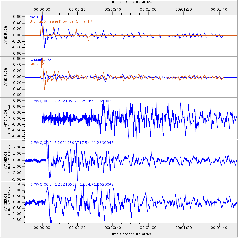
Signal To Noise
| Channel | StoN | STA | LTA |
| IC:WMQ:00:BHZ:20210502T17:54:41.269004Z | 9.215608 | 1.3542435E-6 | 1.469511E-7 |
| IC:WMQ:00:BH1:20210502T17:54:41.269004Z | 5.0386047 | 6.996161E-7 | 1.3885116E-7 |
| IC:WMQ:00:BH2:20210502T17:54:41.269004Z | 2.3707135 | 3.2520092E-7 | 1.3717428E-7 |
| Arrivals |
| Ps | 7.1 SECOND |
| PpPs | 25 SECOND |
| PsPs/PpSs | 32 SECOND |


