You are here: Home > Network List > IU - Global Seismograph Network (GSN - IRIS/USGS) Stations List
> Station PMG Port Moresby, New Guinea > Earthquake Result Viewer
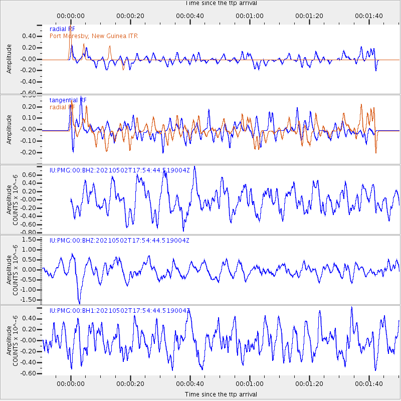
PMG Port Moresby, New Guinea - Earthquake Result Viewer
*The percent match for this event was below the threshold and hence no stack was calculated.
| Earthquake location: |
Southern Sumatra, Indonesia |
| Earthquake latitude/longitude: |
-2.3/99.8 |
| Earthquake time(UTC): |
2021/05/02 (122) 17:46:41 GMT |
| Earthquake Depth: |
21 km |
| Earthquake Magnitude: |
5.5 mww |
| Earthquake Catalog/Contributor: |
NEIC PDE/us |
|
| Network: |
IU Global Seismograph Network (GSN - IRIS/USGS) |
| Station: |
PMG Port Moresby, New Guinea |
| Lat/Lon: |
9.40 S/147.16 E |
| Elevation: |
90 m |
|
| Distance: |
47.6 deg |
| Az: |
100.586 deg |
| Baz: |
275.493 deg |
| Ray Param: |
$rayparam |
*The percent match for this event was below the threshold and hence was not used in the summary stack. |
|
| Radial Match: |
47.128048 % |
| Radial Bump: |
400 |
| Transverse Match: |
59.876217 % |
| Transverse Bump: |
400 |
| SOD ConfigId: |
25028951 |
| Insert Time: |
2021-06-02 22:58:42.158 +0000 |
| GWidth: |
2.5 |
| Max Bumps: |
400 |
| Tol: |
0.001 |
|
Signal To Noise
| Channel | StoN | STA | LTA |
| IU:PMG:00:BHZ:20210502T17:54:44.519004Z | 2.5880044 | 7.721095E-7 | 2.9834166E-7 |
| IU:PMG:00:BH1:20210502T17:54:44.519004Z | 1.4724933 | 2.7727606E-7 | 1.8830377E-7 |
| IU:PMG:00:BH2:20210502T17:54:44.519004Z | 1.3204871 | 4.1580122E-7 | 3.1488472E-7 |
| Arrivals |
| Ps | |
| PpPs | |
| PsPs/PpSs | |


