You are here: Home > Network List > IU - Global Seismograph Network (GSN - IRIS/USGS) Stations List
> Station PMG Port Moresby, New Guinea > Earthquake Result Viewer
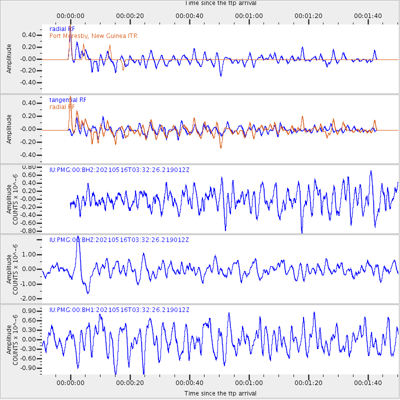
PMG Port Moresby, New Guinea - Earthquake Result Viewer
*The percent match for this event was below the threshold and hence no stack was calculated.
| Earthquake location: |
Hokkaido, Japan Region |
| Earthquake latitude/longitude: |
42.0/144.5 |
| Earthquake time(UTC): |
2021/05/16 (136) 03:23:54 GMT |
| Earthquake Depth: |
17 km |
| Earthquake Magnitude: |
5.7 mww |
| Earthquake Catalog/Contributor: |
NEIC PDE/us |
|
| Network: |
IU Global Seismograph Network (GSN - IRIS/USGS) |
| Station: |
PMG Port Moresby, New Guinea |
| Lat/Lon: |
9.40 S/147.16 E |
| Elevation: |
90 m |
|
| Distance: |
51.2 deg |
| Az: |
176.601 deg |
| Baz: |
357.435 deg |
| Ray Param: |
$rayparam |
*The percent match for this event was below the threshold and hence was not used in the summary stack. |
|
| Radial Match: |
63.265167 % |
| Radial Bump: |
400 |
| Transverse Match: |
54.375977 % |
| Transverse Bump: |
400 |
| SOD ConfigId: |
25028951 |
| Insert Time: |
2021-06-03 01:52:41.708 +0000 |
| GWidth: |
2.5 |
| Max Bumps: |
400 |
| Tol: |
0.001 |
|
Signal To Noise
| Channel | StoN | STA | LTA |
| IU:PMG:00:BHZ:20210516T03:32:26.219012Z | 5.344872 | 1.0317781E-6 | 1.9304075E-7 |
| IU:PMG:00:BH1:20210516T03:32:26.219012Z | 1.814588 | 3.711788E-7 | 2.0455266E-7 |
| IU:PMG:00:BH2:20210516T03:32:26.219012Z | 1.4025836 | 1.9548351E-7 | 1.3937387E-7 |
| Arrivals |
| Ps | |
| PpPs | |
| PsPs/PpSs | |


