You are here: Home > Network List > PR - Puerto Rico Seismic Network (PRSN) & Puerto Rico Strong Motion Program (PRSMP) Stations List
> Station IGPR IGPR > Earthquake Result Viewer
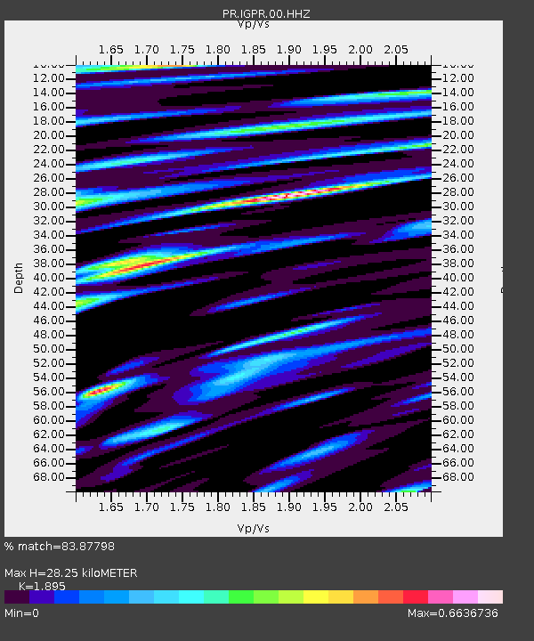
IGPR IGPR - Earthquake Result Viewer
| Earthquake location: |
Southern East Pacific Rise |
| Earthquake latitude/longitude: |
-33.1/-109.4 |
| Earthquake time(UTC): |
2021/05/19 (139) 00:42:19 GMT |
| Earthquake Depth: |
10 km |
| Earthquake Magnitude: |
6.7 mww |
| Earthquake Catalog/Contributor: |
NEIC PDE/us |
|
| Network: |
PR Puerto Rico Seismic Network (PRSN) & Puerto Rico Strong Motion Program (PRSMP) |
| Station: |
IGPR IGPR |
| Lat/Lon: |
17.97 N/66.11 W |
| Elevation: |
10 m |
|
| Distance: |
65.5 deg |
| Az: |
45.845 deg |
| Baz: |
219.268 deg |
| Ray Param: |
0.058257688 |
| Estimated Moho Depth: |
28.25 km |
| Estimated Crust Vp/Vs: |
1.89 |
| Assumed Crust Vp: |
4.082 km/s |
| Estimated Crust Vs: |
2.154 km/s |
| Estimated Crust Poisson's Ratio: |
0.31 |
|
| Radial Match: |
83.87798 % |
| Radial Bump: |
400 |
| Transverse Match: |
78.84758 % |
| Transverse Bump: |
340 |
| SOD ConfigId: |
25028951 |
| Insert Time: |
2021-06-03 02:12:22.284 +0000 |
| GWidth: |
2.5 |
| Max Bumps: |
400 |
| Tol: |
0.001 |
|

Signal To Noise
| Channel | StoN | STA | LTA |
| PR:IGPR:00:HHZ:20210519T00:52:31.560009Z | 4.4860225 | 6.77282E-7 | 1.5097605E-7 |
| PR:IGPR:00:HH1:20210519T00:52:31.560009Z | 1.8053497 | 2.808663E-7 | 1.5557444E-7 |
| PR:IGPR:00:HH2:20210519T00:52:31.560009Z | 1.6767327 | 2.1428183E-7 | 1.2779725E-7 |
| Arrivals |
| Ps | 6.3 SECOND |
| PpPs | 20 SECOND |
| PsPs/PpSs | 26 SECOND |


