You are here: Home > Network List > IU - Global Seismograph Network (GSN - IRIS/USGS) Stations List
> Station PMG Port Moresby, New Guinea > Earthquake Result Viewer
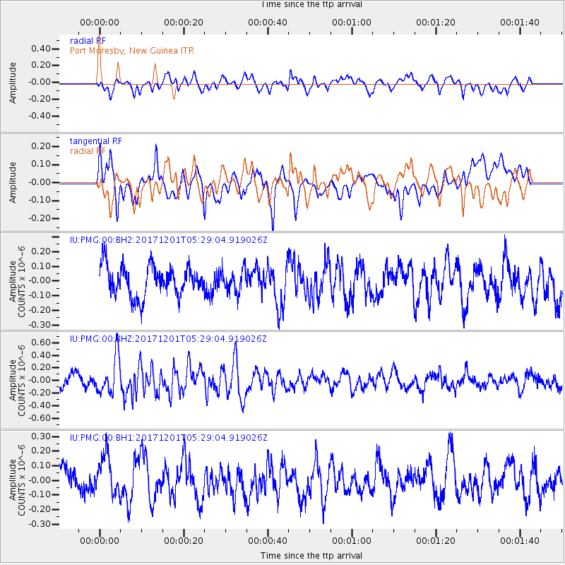
PMG Port Moresby, New Guinea - Earthquake Result Viewer
*The percent match for this event was below the threshold and hence no stack was calculated.
| Earthquake location: |
Southeast Indian Ridge |
| Earthquake latitude/longitude: |
-48.8/106.8 |
| Earthquake time(UTC): |
2017/12/01 (335) 05:20:28 GMT |
| Earthquake Depth: |
10 km |
| Earthquake Magnitude: |
5.5 Mww |
| Earthquake Catalog/Contributor: |
NEIC PDE/us |
|
| Network: |
IU Global Seismograph Network (GSN - IRIS/USGS) |
| Station: |
PMG Port Moresby, New Guinea |
| Lat/Lon: |
9.40 S/147.16 E |
| Elevation: |
90 m |
|
| Distance: |
51.7 deg |
| Az: |
54.431 deg |
| Baz: |
213.044 deg |
| Ray Param: |
$rayparam |
*The percent match for this event was below the threshold and hence was not used in the summary stack. |
|
| Radial Match: |
49.35935 % |
| Radial Bump: |
400 |
| Transverse Match: |
63.121166 % |
| Transverse Bump: |
400 |
| SOD ConfigId: |
2429771 |
| Insert Time: |
2017-12-15 13:01:05.561 +0000 |
| GWidth: |
2.5 |
| Max Bumps: |
400 |
| Tol: |
0.001 |
|
Signal To Noise
| Channel | StoN | STA | LTA |
| IU:PMG:00:BHZ:20171201T05:29:04.919026Z | 3.422527 | 3.0269592E-7 | 8.8442235E-8 |
| IU:PMG:00:BH1:20171201T05:29:04.919026Z | 1.4591459 | 1.4425113E-7 | 9.885998E-8 |
| IU:PMG:00:BH2:20171201T05:29:04.919026Z | 0.735296 | 7.541434E-8 | 1.0256325E-7 |
| Arrivals |
| Ps | |
| PpPs | |
| PsPs/PpSs | |


