You are here: Home > Network List > CN - Canadian National Seismograph Network Stations List
> Station BRWY Burwash Landing, YT, CA > Earthquake Result Viewer
BRWY Burwash Landing, YT, CA - Earthquake Result Viewer
| Earthquake location: |
Solomon Islands |
| Earthquake latitude/longitude: |
-9.9/160.4 |
| Earthquake time(UTC): |
2021/05/21 (141) 01:37:36 GMT |
| Earthquake Depth: |
16 km |
| Earthquake Magnitude: |
5.4 Mww |
| Earthquake Catalog/Contributor: |
NEIC PDE/us |
|
| Network: |
CN Canadian National Seismograph Network |
| Station: |
BRWY Burwash Landing, YT, CA |
| Lat/Lon: |
61.37 N/139.03 W |
| Elevation: |
802 m |
|
| Distance: |
85.2 deg |
| Az: |
24.882 deg |
| Baz: |
239.402 deg |
| Ray Param: |
0.044931702 |
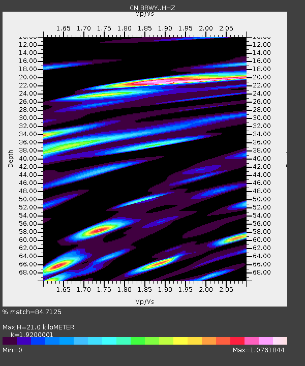
| Estimated Moho Depth: |
21.0 km |
| Estimated Crust Vp/Vs: |
1.92 |
| Assumed Crust Vp: |
6.566 km/s |
| Estimated Crust Vs: |
3.42 km/s |
| Estimated Crust Poisson's Ratio: |
0.31 |
|
| Radial Match: |
84.7125 % |
| Radial Bump: |
400 |
| Transverse Match: |
64.85446 % |
| Transverse Bump: |
400 |
| SOD ConfigId: |
25028951 |
| Insert Time: |
2021-06-04 01:43:55.206 +0000 |
| GWidth: |
2.5 |
| Max Bumps: |
400 |
| Tol: |
0.001 |
|

Signal To Noise
| Channel | StoN | STA | LTA |
| CN:BRWY: :HHZ:20210521T01:49:40.119987Z | 8.565323 | 1.1634529E-6 | 1.3583293E-7 |
| CN:BRWY: :HHN:20210521T01:49:40.119987Z | 2.5963511 | 3.9276256E-7 | 1.5127482E-7 |
| CN:BRWY: :HHE:20210521T01:49:40.119987Z | 4.5317802 | 6.805644E-7 | 1.5017596E-7 |
| Arrivals |
| Ps | 3.0 SECOND |
| PpPs | 9.1 SECOND |
| PsPs/PpSs | 12 SECOND |


