You are here: Home > Network List > CO - South Carolina Seismic Network Stations List
> Station HODGE CO:HODGE > Earthquake Result Viewer
HODGE CO:HODGE - Earthquake Result Viewer
| Earthquake location: |
Near Coast Of Ecuador |
| Earthquake latitude/longitude: |
-0.5/-80.3 |
| Earthquake time(UTC): |
2017/12/03 (337) 11:19:06 GMT |
| Earthquake Depth: |
25 km |
| Earthquake Magnitude: |
6.0 Mww |
| Earthquake Catalog/Contributor: |
NEIC PDE/us |
|
| Network: |
CO South Carolina Seismic Network |
| Station: |
HODGE CO:HODGE |
| Lat/Lon: |
34.23 N/82.26 W |
| Elevation: |
151 m |
|
| Distance: |
34.6 deg |
| Az: |
357.115 deg |
| Baz: |
176.517 deg |
| Ray Param: |
0.07762978 |
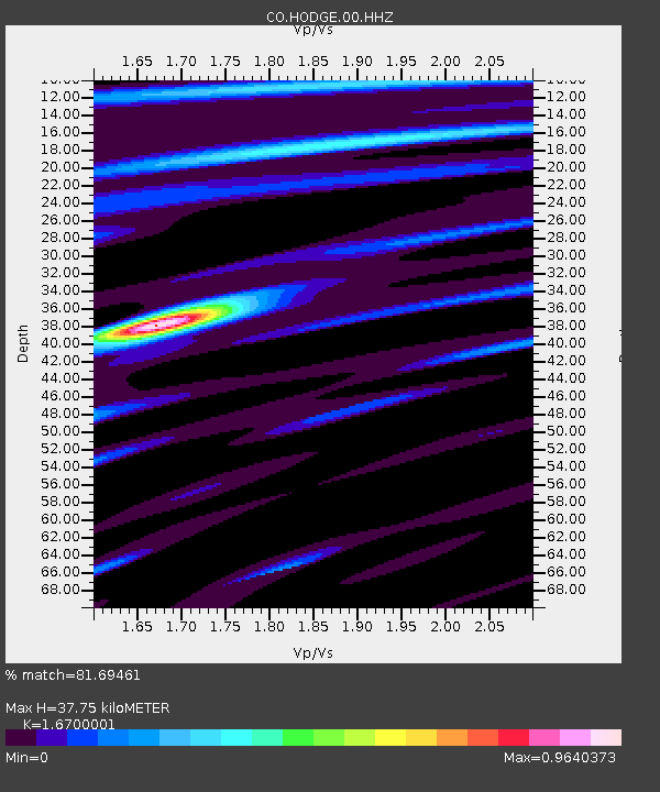
| Estimated Moho Depth: |
37.75 km |
| Estimated Crust Vp/Vs: |
1.67 |
| Assumed Crust Vp: |
6.35 km/s |
| Estimated Crust Vs: |
3.802 km/s |
| Estimated Crust Poisson's Ratio: |
0.22 |
|
| Radial Match: |
81.69461 % |
| Radial Bump: |
334 |
| Transverse Match: |
51.181717 % |
| Transverse Bump: |
400 |
| SOD ConfigId: |
2429771 |
| Insert Time: |
2017-12-17 11:20:19.626 +0000 |
| GWidth: |
2.5 |
| Max Bumps: |
400 |
| Tol: |
0.001 |
|

Signal To Noise
| Channel | StoN | STA | LTA |
| CO:HODGE:00:HHZ:20171203T11:25:22.940005Z | 7.616051 | 7.547042E-7 | 9.90939E-8 |
| CO:HODGE:00:HHN:20171203T11:25:22.940005Z | 5.6482105 | 4.0780714E-7 | 7.2201125E-8 |
| CO:HODGE:00:HHE:20171203T11:25:22.940005Z | 0.9455021 | 9.889882E-8 | 1.0459926E-7 |
| Arrivals |
| Ps | 4.3 SECOND |
| PpPs | 15 SECOND |
| PsPs/PpSs | 19 SECOND |


