You are here: Home > Network List > KZ - Kazakhstan Network Stations List
> Station AKT Aktyubinsk, Kazakstan > Earthquake Result Viewer
AKT Aktyubinsk, Kazakstan - Earthquake Result Viewer
| Earthquake location: |
Eastern Sea Of Japan |
| Earthquake latitude/longitude: |
43.2/138.9 |
| Earthquake time(UTC): |
1996/12/22 (357) 14:53:27 GMT |
| Earthquake Depth: |
227 km |
| Earthquake Magnitude: |
6.0 MB, 6.5 UNKNOWN, 6.5 MW |
| Earthquake Catalog/Contributor: |
WHDF/NEIC |
|
| Network: |
KZ Kazakhstan Network |
| Station: |
AKT Aktyubinsk, Kazakstan |
| Lat/Lon: |
50.43 N/58.02 E |
| Elevation: |
360 m |
|
| Distance: |
53.2 deg |
| Az: |
307.989 deg |
| Baz: |
64.305 deg |
| Ray Param: |
0.06541684 |
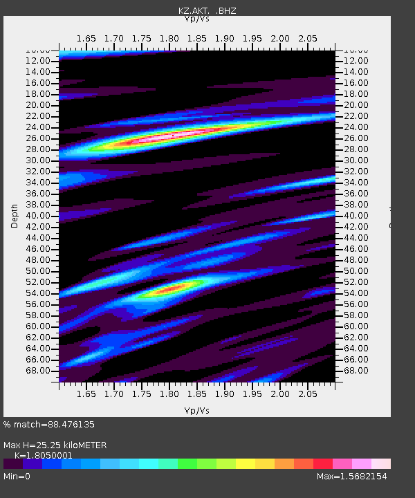
| Estimated Moho Depth: |
25.25 km |
| Estimated Crust Vp/Vs: |
1.81 |
| Assumed Crust Vp: |
6.353 km/s |
| Estimated Crust Vs: |
3.52 km/s |
| Estimated Crust Poisson's Ratio: |
0.28 |
|
| Radial Match: |
88.476135 % |
| Radial Bump: |
400 |
| Transverse Match: |
79.36688 % |
| Transverse Bump: |
400 |
| SOD ConfigId: |
4480 |
| Insert Time: |
2010-03-09 08:35:26.964 +0000 |
| GWidth: |
2.5 |
| Max Bumps: |
400 |
| Tol: |
0.001 |
|

Signal To Noise
| Channel | StoN | STA | LTA |
| KZ:AKT: :BHZ:19961222T15:01:52.033014Z | 61.56366 | 5.506954E-6 | 8.9451376E-8 |
| KZ:AKT: :BHN:19961222T15:01:52.033014Z | 24.243645 | 2.5634995E-6 | 1.05739026E-7 |
| KZ:AKT: :BHE:19961222T15:01:52.033014Z | 33.721733 | 2.7179874E-6 | 8.060047E-8 |
| Arrivals |
| Ps | 3.4 SECOND |
| PpPs | 11 SECOND |
| PsPs/PpSs | 14 SECOND |


