You are here: Home > Network List > GS - US Geological Survey Networks Stations List
> Station KAN06 Argonia West Station > Earthquake Result Viewer
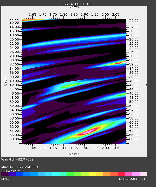
KAN06 Argonia West Station - Earthquake Result Viewer
| Earthquake location: |
Near Coast Of Ecuador |
| Earthquake latitude/longitude: |
-0.5/-80.3 |
| Earthquake time(UTC): |
2017/12/03 (337) 11:19:06 GMT |
| Earthquake Depth: |
25 km |
| Earthquake Magnitude: |
6.0 Mww |
| Earthquake Catalog/Contributor: |
NEIC PDE/us |
|
| Network: |
GS US Geological Survey Networks |
| Station: |
KAN06 Argonia West Station |
| Lat/Lon: |
37.25 N/97.86 W |
| Elevation: |
393 m |
|
| Distance: |
40.9 deg |
| Az: |
338.414 deg |
| Baz: |
152.547 deg |
| Ray Param: |
0.074074 |
| Estimated Moho Depth: |
30.5 km |
| Estimated Crust Vp/Vs: |
2.10 |
| Assumed Crust Vp: |
6.483 km/s |
| Estimated Crust Vs: |
3.091 km/s |
| Estimated Crust Poisson's Ratio: |
0.35 |
|
| Radial Match: |
82.97019 % |
| Radial Bump: |
400 |
| Transverse Match: |
70.03525 % |
| Transverse Bump: |
400 |
| SOD ConfigId: |
2429771 |
| Insert Time: |
2017-12-17 11:21:45.241 +0000 |
| GWidth: |
2.5 |
| Max Bumps: |
400 |
| Tol: |
0.001 |
|

Signal To Noise
| Channel | StoN | STA | LTA |
| GS:KAN06:01:HHZ:20171203T11:26:16.355013Z | 5.832559 | 4.8618097E-7 | 8.3356376E-8 |
| GS:KAN06:01:HHN:20171203T11:26:16.355013Z | 2.5969841 | 3.1317356E-7 | 1.2059124E-7 |
| GS:KAN06:01:HHE:20171203T11:26:16.355013Z | 0.89918804 | 1.2608591E-7 | 1.4022196E-7 |
| Arrivals |
| Ps | 5.5 SECOND |
| PpPs | 14 SECOND |
| PsPs/PpSs | 19 SECOND |


