You are here: Home > Network List > GS - US Geological Survey Networks Stations List
> Station KAN10 Keim Farm > Earthquake Result Viewer
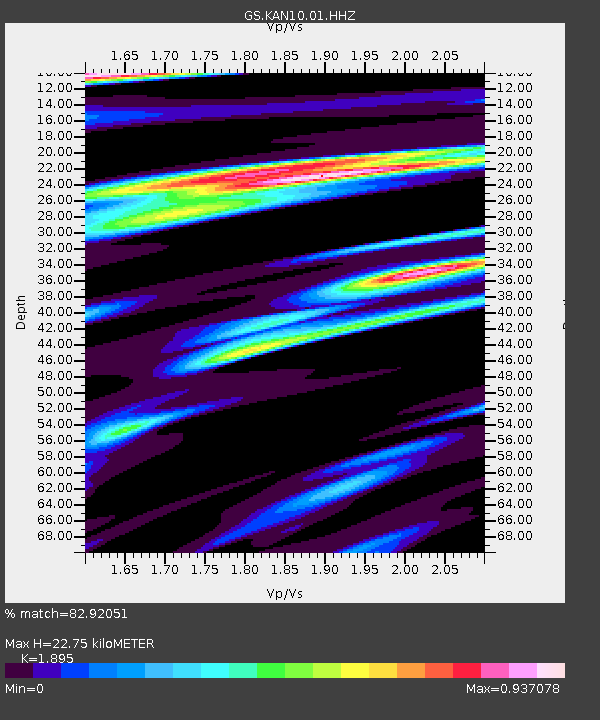
KAN10 Keim Farm - Earthquake Result Viewer
| Earthquake location: |
Near Coast Of Ecuador |
| Earthquake latitude/longitude: |
-0.5/-80.3 |
| Earthquake time(UTC): |
2017/12/03 (337) 11:19:06 GMT |
| Earthquake Depth: |
25 km |
| Earthquake Magnitude: |
6.0 Mww |
| Earthquake Catalog/Contributor: |
NEIC PDE/us |
|
| Network: |
GS US Geological Survey Networks |
| Station: |
KAN10 Keim Farm |
| Lat/Lon: |
37.12 N/98.10 W |
| Elevation: |
417 m |
|
| Distance: |
40.9 deg |
| Az: |
338.071 deg |
| Baz: |
152.145 deg |
| Ray Param: |
0.07408778 |
| Estimated Moho Depth: |
22.75 km |
| Estimated Crust Vp/Vs: |
1.89 |
| Assumed Crust Vp: |
6.426 km/s |
| Estimated Crust Vs: |
3.391 km/s |
| Estimated Crust Poisson's Ratio: |
0.31 |
|
| Radial Match: |
82.92051 % |
| Radial Bump: |
400 |
| Transverse Match: |
57.266525 % |
| Transverse Bump: |
400 |
| SOD ConfigId: |
2429771 |
| Insert Time: |
2017-12-17 11:21:50.416 +0000 |
| GWidth: |
2.5 |
| Max Bumps: |
400 |
| Tol: |
0.001 |
|

Signal To Noise
| Channel | StoN | STA | LTA |
| GS:KAN10:01:HHZ:20171203T11:26:16.169009Z | 3.4557421 | 3.654939E-7 | 1.0576422E-7 |
| GS:KAN10:01:HHN:20171203T11:26:16.169009Z | 2.08172 | 2.2430638E-7 | 1.07750495E-7 |
| GS:KAN10:01:HHE:20171203T11:26:16.169009Z | 3.0640492 | 4.818722E-7 | 1.5726646E-7 |
| Arrivals |
| Ps | 3.4 SECOND |
| PpPs | 9.6 SECOND |
| PsPs/PpSs | 13 SECOND |


