You are here: Home > Network List > AK - Alaska Regional Network Stations List
> Station H23K Yukon River, AK, USA > Earthquake Result Viewer
H23K Yukon River, AK, USA - Earthquake Result Viewer
| Earthquake location: |
Qinghai, China |
| Earthquake latitude/longitude: |
34.6/98.2 |
| Earthquake time(UTC): |
2021/05/21 (141) 18:04:13 GMT |
| Earthquake Depth: |
10 km |
| Earthquake Magnitude: |
7.3 Mww |
| Earthquake Catalog/Contributor: |
NEIC PDE/us |
|
| Network: |
AK Alaska Regional Network |
| Station: |
H23K Yukon River, AK, USA |
| Lat/Lon: |
65.83 N/149.54 W |
| Elevation: |
617 m |
|
| Distance: |
67.2 deg |
| Az: |
24.422 deg |
| Baz: |
304.099 deg |
| Ray Param: |
0.057093557 |
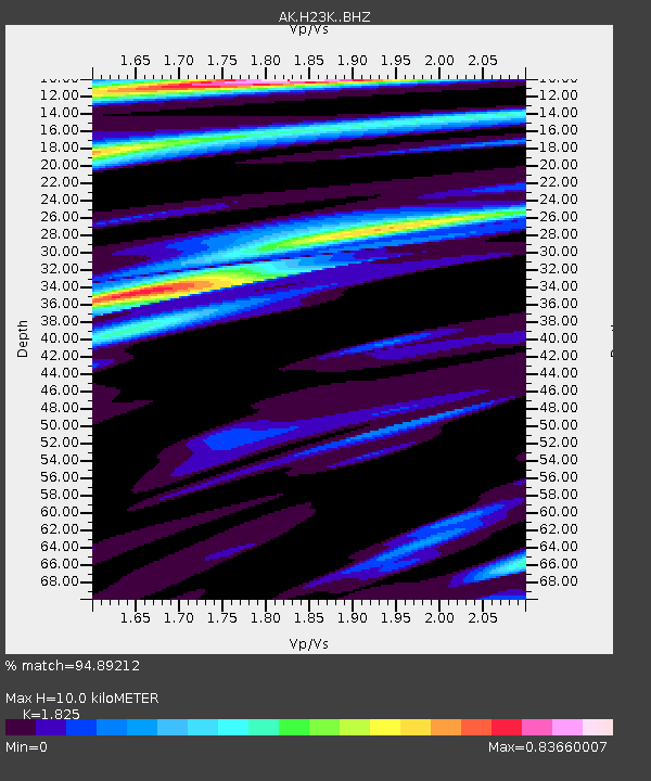
| Estimated Moho Depth: |
10.0 km |
| Estimated Crust Vp/Vs: |
1.83 |
| Assumed Crust Vp: |
6.566 km/s |
| Estimated Crust Vs: |
3.598 km/s |
| Estimated Crust Poisson's Ratio: |
0.29 |
|
| Radial Match: |
94.89212 % |
| Radial Bump: |
323 |
| Transverse Match: |
84.05547 % |
| Transverse Bump: |
400 |
| SOD ConfigId: |
25028951 |
| Insert Time: |
2021-06-04 18:05:55.174 +0000 |
| GWidth: |
2.5 |
| Max Bumps: |
400 |
| Tol: |
0.001 |
|

Signal To Noise
| Channel | StoN | STA | LTA |
| AK:H23K: :BHZ:20210521T18:14:36.800Z | 2.4065 | 3.2255303E-7 | 1.3403408E-7 |
| AK:H23K: :BHN:20210521T18:14:36.800Z | 0.8896545 | 1.271147E-7 | 1.4288096E-7 |
| AK:H23K: :BHE:20210521T18:14:36.800Z | 0.9994809 | 1.0180414E-7 | 1.0185701E-7 |
| Arrivals |
| Ps | 1.3 SECOND |
| PpPs | 4.1 SECOND |
| PsPs/PpSs | 5.4 SECOND |


