You are here: Home > Network List > GS - US Geological Survey Networks Stations List
> Station KAN09 Caldwell North Station > Earthquake Result Viewer
KAN09 Caldwell North Station - Earthquake Result Viewer

| Earthquake location: |
Near Coast Of Ecuador |
| Earthquake latitude/longitude: |
-0.5/-80.3 |
| Earthquake time(UTC): |
2017/12/03 (337) 11:19:06 GMT |
| Earthquake Depth: |
25 km |
| Earthquake Magnitude: |
6.0 Mww |
| Earthquake Catalog/Contributor: |
NEIC PDE/us |
|
| Network: |
GS US Geological Survey Networks |
| Station: |
KAN09 Caldwell North Station |
| Lat/Lon: |
37.14 N/97.62 W |
| Elevation: |
371 m |
|
| Distance: |
40.7 deg |
| Az: |
338.597 deg |
| Baz: |
152.83 deg |
| Ray Param: |
0.07418786 |
| Estimated Moho Depth: |
39.25 km |
| Estimated Crust Vp/Vs: |
1.94 |
| Assumed Crust Vp: |
6.483 km/s |
| Estimated Crust Vs: |
3.337 km/s |
| Estimated Crust Poisson's Ratio: |
0.32 |
|
| Radial Match: |
85.04361 % |
| Radial Bump: |
320 |
| Transverse Match: |
53.264183 % |
| Transverse Bump: |
400 |
| SOD ConfigId: |
2429771 |
| Insert Time: |
2017-12-17 11:21:50.795 +0000 |
| GWidth: |
2.5 |
| Max Bumps: |
400 |
| Tol: |
0.001 |
|
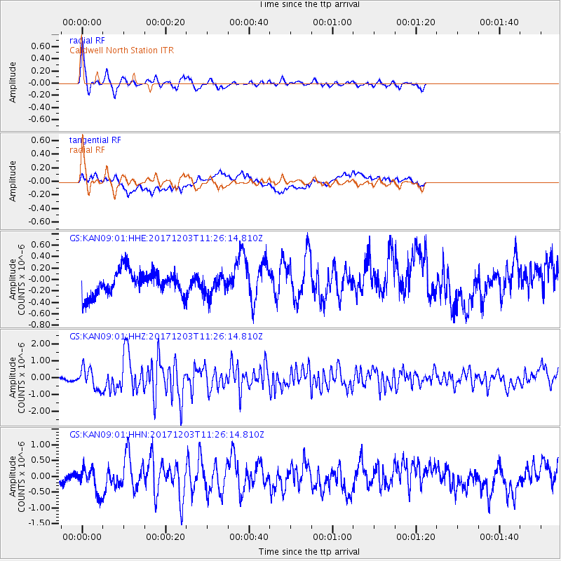
Signal To Noise
| Channel | StoN | STA | LTA |
| GS:KAN09:01:HHZ:20171203T11:26:14.810Z | 5.3327255 | 6.317135E-7 | 1.1845979E-7 |
| GS:KAN09:01:HHN:20171203T11:26:14.810Z | 2.8841722 | 4.1248188E-7 | 1.430157E-7 |
| GS:KAN09:01:HHE:20171203T11:26:14.810Z | 0.8580464 | 1.81245E-7 | 2.1122985E-7 |
| Arrivals |
| Ps | 6.1 SECOND |
| PpPs | 17 SECOND |
| PsPs/PpSs | 23 SECOND |


