You are here: Home > Network List > AV - Alaska Volcano Observatory Stations List
> Station GAKI Kavalga Island, Gareloi Volcano, Alaska > Earthquake Result Viewer
GAKI Kavalga Island, Gareloi Volcano, Alaska - Earthquake Result Viewer
| Earthquake location: |
Qinghai, China |
| Earthquake latitude/longitude: |
34.6/98.2 |
| Earthquake time(UTC): |
2021/05/21 (141) 18:04:13 GMT |
| Earthquake Depth: |
10 km |
| Earthquake Magnitude: |
7.3 Mww |
| Earthquake Catalog/Contributor: |
NEIC PDE/us |
|
| Network: |
AV Alaska Volcano Observatory |
| Station: |
GAKI Kavalga Island, Gareloi Volcano, Alaska |
| Lat/Lon: |
51.55 N/178.81 W |
| Elevation: |
99 m |
|
| Distance: |
59.7 deg |
| Az: |
45.879 deg |
| Baz: |
288.498 deg |
| Ray Param: |
0.062037103 |
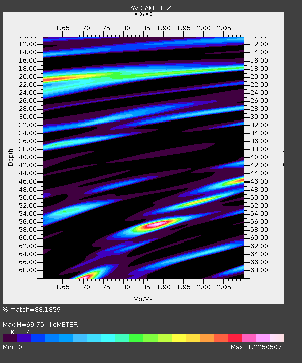
| Estimated Moho Depth: |
69.75 km |
| Estimated Crust Vp/Vs: |
1.70 |
| Assumed Crust Vp: |
6.048 km/s |
| Estimated Crust Vs: |
3.558 km/s |
| Estimated Crust Poisson's Ratio: |
0.24 |
|
| Radial Match: |
88.1859 % |
| Radial Bump: |
400 |
| Transverse Match: |
74.86811 % |
| Transverse Bump: |
400 |
| SOD ConfigId: |
25028951 |
| Insert Time: |
2021-06-04 18:08:22.931 +0000 |
| GWidth: |
2.5 |
| Max Bumps: |
400 |
| Tol: |
0.001 |
|

Signal To Noise
| Channel | StoN | STA | LTA |
| AV:GAKI: :BHZ:20210521T18:13:46.82002Z | 3.1032083 | 9.703404E-7 | 3.126894E-7 |
| AV:GAKI: :BHN:20210521T18:13:46.82002Z | 0.6994354 | 3.6423722E-7 | 5.2075893E-7 |
| AV:GAKI: :BHE:20210521T18:13:46.82002Z | 1.2608569 | 5.5196415E-7 | 4.3776907E-7 |
| Arrivals |
| Ps | 8.4 SECOND |
| PpPs | 30 SECOND |
| PsPs/PpSs | 38 SECOND |


