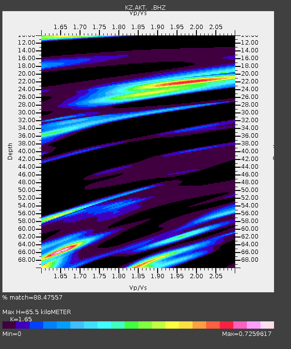
AKT Aktyubinsk, Kazakstan - Earthquake Result Viewer

Earthquake location: Komandorskiye Ostrova Region
Earthquake latitude/longitude: 56.1/165.0
Earthquake time(UTC): 1996/07/16 (198) 03:48:28 GMT
Earthquake Depth: 33 km
Earthquake Magnitude: 5.8 MB, 6.4 MS, 6.5 UNKNOWN, 6.3 MW
Earthquake Catalog/Contributor: WHDF/NEIC
Network: KZ Kazakhstan Network
Station: AKT Aktyubinsk, Kazakstan
Lat/Lon: 50.43 N/58.02 E
Elevation: 360 m
Distance: 57.9 deg
Az: 313.756 deg
Baz: 39.281 deg
Ray Param: 0.06316181
Estimated Moho Depth: 65.5 km
Estimated Crust Vp/Vs: 1.65
Assumed Crust Vp: 6.353 km/s
Estimated Crust Vs: 3.85 km/s
Estimated Crust Poisson's Ratio: 0.21
Radial Match: 88.47557 %
Radial Bump: 400
Transverse Match: 46.539906 %
Transverse Bump: 400
SOD ConfigId: 4480
Insert Time: 2010-03-09 08:35:51.782 +0000
GWidth: 2.5
Max Bumps: 400
Tol: 0.001

Signal To Noise

ChannelStoNSTALTA
KZ:AKT: :BHZ:19960716T03:57:46.068005Z14.7666856.5369034E-74.4267917E-8
KZ:AKT: :BHN:19960716T03:57:46.068005Z4.41196352.945583E-76.676354E-8
KZ:AKT: :BHE:19960716T03:57:46.068005Z0.83684933.9097276E-74.6719612E-7
Arrivals
Ps7.1 SECOND
PpPs26 SECOND
PsPs/PpSs33 SECOND