You are here: Home > Network List > GS - US Geological Survey Networks Stations List
> Station OK051 E0350 and S34600 Roads, Ralston, OK > Earthquake Result Viewer
OK051 E0350 and S34600 Roads, Ralston, OK - Earthquake Result Viewer
| Earthquake location: |
Near Coast Of Ecuador |
| Earthquake latitude/longitude: |
-0.5/-80.3 |
| Earthquake time(UTC): |
2017/12/03 (337) 11:19:06 GMT |
| Earthquake Depth: |
25 km |
| Earthquake Magnitude: |
6.0 Mww |
| Earthquake Catalog/Contributor: |
NEIC PDE/us |
|
| Network: |
GS US Geological Survey Networks |
| Station: |
OK051 E0350 and S34600 Roads, Ralston, OK |
| Lat/Lon: |
36.51 N/96.84 W |
| Elevation: |
263 m |
|
| Distance: |
39.9 deg |
| Az: |
339.024 deg |
| Baz: |
153.623 deg |
| Ray Param: |
0.074678615 |
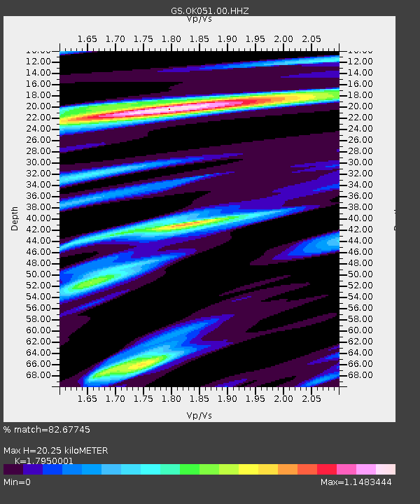
| Estimated Moho Depth: |
20.25 km |
| Estimated Crust Vp/Vs: |
1.80 |
| Assumed Crust Vp: |
6.483 km/s |
| Estimated Crust Vs: |
3.611 km/s |
| Estimated Crust Poisson's Ratio: |
0.27 |
|
| Radial Match: |
82.67745 % |
| Radial Bump: |
400 |
| Transverse Match: |
55.079643 % |
| Transverse Bump: |
400 |
| SOD ConfigId: |
2429771 |
| Insert Time: |
2017-12-17 11:22:26.028 +0000 |
| GWidth: |
2.5 |
| Max Bumps: |
400 |
| Tol: |
0.001 |
|
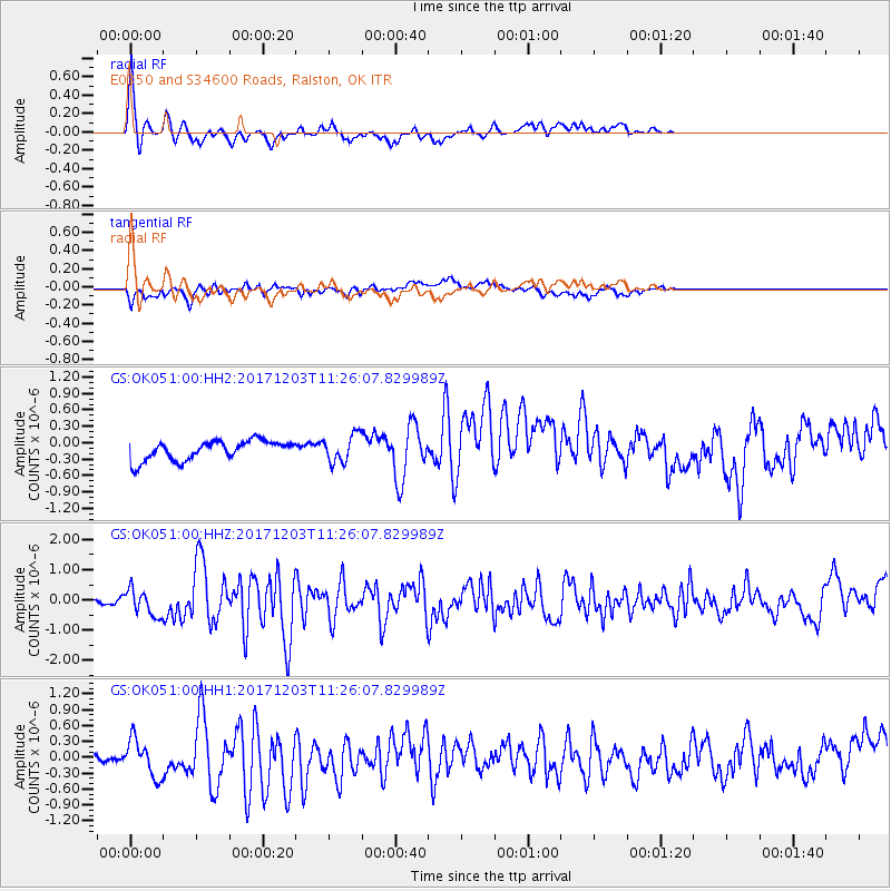
Signal To Noise
| Channel | StoN | STA | LTA |
| GS:OK051:00:HHZ:20171203T11:26:07.829989Z | 3.2875826 | 4.312164E-7 | 1.3116518E-7 |
| GS:OK051:00:HH1:20171203T11:26:07.829989Z | 2.4770877 | 3.5381873E-7 | 1.4283658E-7 |
| GS:OK051:00:HH2:20171203T11:26:07.829989Z | 1.4079573 | 2.4943884E-7 | 1.7716366E-7 |
| Arrivals |
| Ps | 2.7 SECOND |
| PpPs | 8.1 SECOND |
| PsPs/PpSs | 11 SECOND |


