You are here: Home > Network List > GT - Global Telemetered Seismograph Network (USAF/USGS) Stations List
> Station PLCA Paso Flores, Argentina > Earthquake Result Viewer
PLCA Paso Flores, Argentina - Earthquake Result Viewer

| Earthquake location: |
Near Coast Of Ecuador |
| Earthquake latitude/longitude: |
-0.5/-80.3 |
| Earthquake time(UTC): |
2017/12/03 (337) 11:19:06 GMT |
| Earthquake Depth: |
25 km |
| Earthquake Magnitude: |
6.0 Mww |
| Earthquake Catalog/Contributor: |
NEIC PDE/us |
|
| Network: |
GT Global Telemetered Seismograph Network (USAF/USGS) |
| Station: |
PLCA Paso Flores, Argentina |
| Lat/Lon: |
40.73 S/70.55 W |
| Elevation: |
1050 m |
|
| Distance: |
41.0 deg |
| Az: |
168.715 deg |
| Baz: |
345.078 deg |
| Ray Param: |
0.074008815 |
| Estimated Moho Depth: |
10.75 km |
| Estimated Crust Vp/Vs: |
2.10 |
| Assumed Crust Vp: |
6.597 km/s |
| Estimated Crust Vs: |
3.145 km/s |
| Estimated Crust Poisson's Ratio: |
0.35 |
|
| Radial Match: |
82.79891 % |
| Radial Bump: |
400 |
| Transverse Match: |
64.64523 % |
| Transverse Bump: |
400 |
| SOD ConfigId: |
2429771 |
| Insert Time: |
2017-12-17 11:22:32.521 +0000 |
| GWidth: |
2.5 |
| Max Bumps: |
400 |
| Tol: |
0.001 |
|
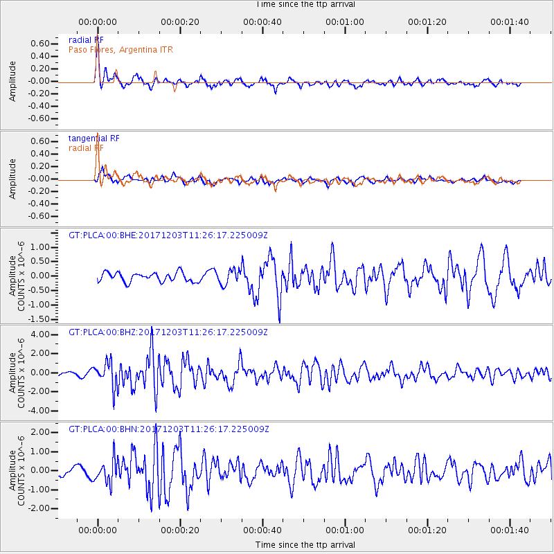
Signal To Noise
| Channel | StoN | STA | LTA |
| GT:PLCA:00:BHZ:20171203T11:26:17.225009Z | 5.3062825 | 1.3025614E-6 | 2.4547532E-7 |
| GT:PLCA:00:BHN:20171203T11:26:17.225009Z | 3.1791534 | 6.1497633E-7 | 1.9344029E-7 |
| GT:PLCA:00:BHE:20171203T11:26:17.225009Z | 1.599575 | 2.5268264E-7 | 1.579686E-7 |
| Arrivals |
| Ps | 1.9 SECOND |
| PpPs | 4.7 SECOND |
| PsPs/PpSs | 6.6 SECOND |


