You are here: Home > Network List > CN - Canadian National Seismograph Network Stations List
> Station TAHB Tahsis, BC, CA > Earthquake Result Viewer
TAHB Tahsis, BC, CA - Earthquake Result Viewer
| Earthquake location: |
Qinghai, China |
| Earthquake latitude/longitude: |
34.6/98.2 |
| Earthquake time(UTC): |
2021/05/21 (141) 18:04:13 GMT |
| Earthquake Depth: |
10 km |
| Earthquake Magnitude: |
7.3 Mww |
| Earthquake Catalog/Contributor: |
NEIC PDE/us |
|
| Network: |
CN Canadian National Seismograph Network |
| Station: |
TAHB Tahsis, BC, CA |
| Lat/Lon: |
49.89 N/126.68 W |
| Elevation: |
455 m |
|
| Distance: |
86.9 deg |
| Az: |
27.217 deg |
| Baz: |
324.319 deg |
| Ray Param: |
0.04369574 |
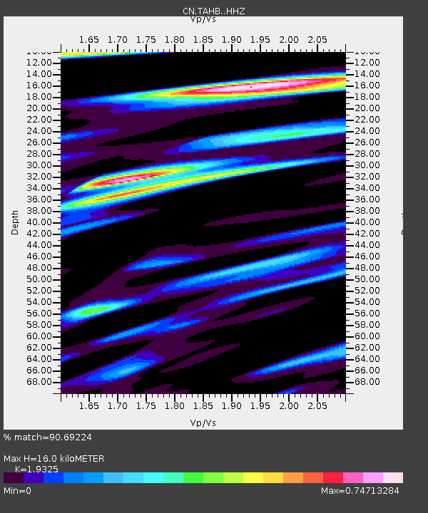
| Estimated Moho Depth: |
16.0 km |
| Estimated Crust Vp/Vs: |
1.93 |
| Assumed Crust Vp: |
6.24 km/s |
| Estimated Crust Vs: |
3.229 km/s |
| Estimated Crust Poisson's Ratio: |
0.32 |
|
| Radial Match: |
90.69224 % |
| Radial Bump: |
400 |
| Transverse Match: |
85.144295 % |
| Transverse Bump: |
400 |
| SOD ConfigId: |
25028951 |
| Insert Time: |
2021-06-04 18:11:37.854 +0000 |
| GWidth: |
2.5 |
| Max Bumps: |
400 |
| Tol: |
0.001 |
|

Signal To Noise
| Channel | StoN | STA | LTA |
| CN:TAHB: :HHZ:20210521T18:16:27.039991Z | 1.2205781 | 1.608503E-7 | 1.3178207E-7 |
| CN:TAHB: :HHN:20210521T18:16:27.039991Z | 1.0881433 | 1.4210607E-7 | 1.30595E-7 |
| CN:TAHB: :HHE:20210521T18:16:27.039991Z | 0.9765101 | 2.4634497E-7 | 2.5227078E-7 |
| Arrivals |
| Ps | 2.4 SECOND |
| PpPs | 7.4 SECOND |
| PsPs/PpSs | 9.8 SECOND |


