You are here: Home > Network List > G - GEOSCOPE Stations List
> Station TAM Tamanrasset, Algeria > Earthquake Result Viewer
TAM Tamanrasset, Algeria - Earthquake Result Viewer

| Earthquake location: |
Qinghai, China |
| Earthquake latitude/longitude: |
34.6/98.2 |
| Earthquake time(UTC): |
2021/05/21 (141) 18:04:13 GMT |
| Earthquake Depth: |
10 km |
| Earthquake Magnitude: |
7.3 Mww |
| Earthquake Catalog/Contributor: |
NEIC PDE/us |
|
| Network: |
G GEOSCOPE |
| Station: |
TAM Tamanrasset, Algeria |
| Lat/Lon: |
22.79 N/5.53 E |
| Elevation: |
1377 m |
|
| Distance: |
79.5 deg |
| Az: |
290.379 deg |
| Baz: |
56.909 deg |
| Ray Param: |
0.04890059 |
| Estimated Moho Depth: |
37.25 km |
| Estimated Crust Vp/Vs: |
1.99 |
| Assumed Crust Vp: |
6.61 km/s |
| Estimated Crust Vs: |
3.326 km/s |
| Estimated Crust Poisson's Ratio: |
0.33 |
|
| Radial Match: |
96.28759 % |
| Radial Bump: |
300 |
| Transverse Match: |
90.90697 % |
| Transverse Bump: |
400 |
| SOD ConfigId: |
25028951 |
| Insert Time: |
2021-06-04 18:12:20.504 +0000 |
| GWidth: |
2.5 |
| Max Bumps: |
400 |
| Tol: |
0.001 |
|
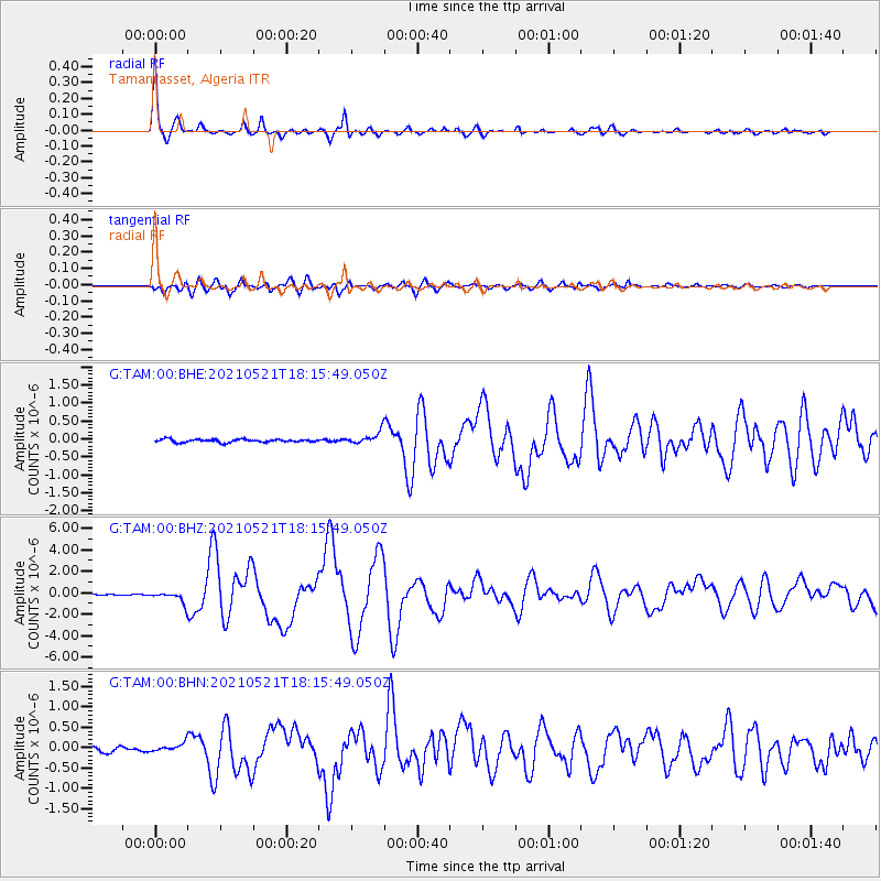
Signal To Noise
| Channel | StoN | STA | LTA |
| G:TAM:00:BHZ:20210521T18:15:49.050Z | 11.252454 | 5.6137577E-7 | 4.988919E-8 |
| G:TAM:00:BHN:20210521T18:15:49.050Z | 2.0026956 | 1.11877625E-7 | 5.5863524E-8 |
| G:TAM:00:BHE:20210521T18:15:49.050Z | 4.2289047 | 1.6995082E-7 | 4.0187906E-8 |
| Arrivals |
| Ps | 5.7 SECOND |
| PpPs | 16 SECOND |
| PsPs/PpSs | 22 SECOND |


