You are here: Home > Network List > NE - New England Seismic Network Stations List
> Station BRYW Smithfield, RI, USA > Earthquake Result Viewer
BRYW Smithfield, RI, USA - Earthquake Result Viewer
| Earthquake location: |
Near Coast Of Ecuador |
| Earthquake latitude/longitude: |
-0.5/-80.3 |
| Earthquake time(UTC): |
2017/12/03 (337) 11:19:06 GMT |
| Earthquake Depth: |
25 km |
| Earthquake Magnitude: |
6.0 Mww |
| Earthquake Catalog/Contributor: |
NEIC PDE/us |
|
| Network: |
NE New England Seismic Network |
| Station: |
BRYW Smithfield, RI, USA |
| Lat/Lon: |
41.92 N/71.54 W |
| Elevation: |
116 m |
|
| Distance: |
42.9 deg |
| Az: |
9.587 deg |
| Baz: |
192.894 deg |
| Ray Param: |
0.07282815 |
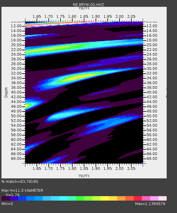
| Estimated Moho Depth: |
11.0 km |
| Estimated Crust Vp/Vs: |
1.74 |
| Assumed Crust Vp: |
6.472 km/s |
| Estimated Crust Vs: |
3.719 km/s |
| Estimated Crust Poisson's Ratio: |
0.25 |
|
| Radial Match: |
83.78195 % |
| Radial Bump: |
400 |
| Transverse Match: |
56.295383 % |
| Transverse Bump: |
400 |
| SOD ConfigId: |
2429771 |
| Insert Time: |
2017-12-17 11:24:04.747 +0000 |
| GWidth: |
2.5 |
| Max Bumps: |
400 |
| Tol: |
0.001 |
|

Signal To Noise
| Channel | StoN | STA | LTA |
| NE:BRYW:00:HHZ:20171203T11:26:32.854006Z | 5.872738 | 8.526179E-7 | 1.4518236E-7 |
| NE:BRYW:00:HH1:20171203T11:26:32.854006Z | 3.1357915 | 4.1466086E-7 | 1.3223483E-7 |
| NE:BRYW:00:HH2:20171203T11:26:32.854006Z | 2.1049473 | 2.483635E-7 | 1.1799037E-7 |
| Arrivals |
| Ps | 1.3 SECOND |
| PpPs | 4.3 SECOND |
| PsPs/PpSs | 5.7 SECOND |


