You are here: Home > Network List > TA - USArray Transportable Network (new EarthScope stations) Stations List
> Station A36M Sachs Harbour, NT, CAN > Earthquake Result Viewer
A36M Sachs Harbour, NT, CAN - Earthquake Result Viewer

| Earthquake location: |
Qinghai, China |
| Earthquake latitude/longitude: |
34.6/98.2 |
| Earthquake time(UTC): |
2021/05/21 (141) 18:04:13 GMT |
| Earthquake Depth: |
10 km |
| Earthquake Magnitude: |
7.3 Mww |
| Earthquake Catalog/Contributor: |
NEIC PDE/us |
|
| Network: |
TA USArray Transportable Network (new EarthScope stations) |
| Station: |
A36M Sachs Harbour, NT, CAN |
| Lat/Lon: |
71.99 N/125.25 W |
| Elevation: |
32 m |
|
| Distance: |
69.4 deg |
| Az: |
13.22 deg |
| Baz: |
322.677 deg |
| Ray Param: |
0.055649567 |
| Estimated Moho Depth: |
37.5 km |
| Estimated Crust Vp/Vs: |
1.75 |
| Assumed Crust Vp: |
6.24 km/s |
| Estimated Crust Vs: |
3.576 km/s |
| Estimated Crust Poisson's Ratio: |
0.26 |
|
| Radial Match: |
95.40096 % |
| Radial Bump: |
400 |
| Transverse Match: |
90.0607 % |
| Transverse Bump: |
400 |
| SOD ConfigId: |
25028951 |
| Insert Time: |
2021-06-04 18:16:33.047 +0000 |
| GWidth: |
2.5 |
| Max Bumps: |
400 |
| Tol: |
0.001 |
|
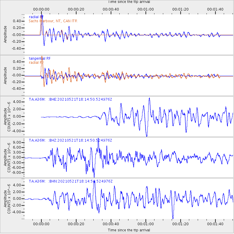
Signal To Noise
| Channel | StoN | STA | LTA |
| TA:A36M: :BHZ:20210521T18:14:50.524976Z | 8.343178 | 6.06441E-7 | 7.268705E-8 |
| TA:A36M: :BHN:20210521T18:14:50.524976Z | 1.8495835 | 1.8514143E-7 | 1.0009898E-7 |
| TA:A36M: :BHE:20210521T18:14:50.524976Z | 2.923538 | 2.5085401E-7 | 8.580495E-8 |
| Arrivals |
| Ps | 4.6 SECOND |
| PpPs | 16 SECOND |
| PsPs/PpSs | 21 SECOND |


