You are here: Home > Network List > AK - Alaska Regional Network Stations List
> Station CCB Clear Creek Butte > Earthquake Result Viewer
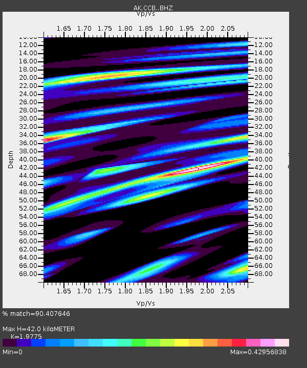
CCB Clear Creek Butte - Earthquake Result Viewer
| Earthquake location: |
Fiji Islands Region |
| Earthquake latitude/longitude: |
-16.6/-177.4 |
| Earthquake time(UTC): |
2021/05/21 (141) 22:13:18 GMT |
| Earthquake Depth: |
10 km |
| Earthquake Magnitude: |
6.5 mww |
| Earthquake Catalog/Contributor: |
NEIC PDE/us |
|
| Network: |
AK Alaska Regional Network |
| Station: |
CCB Clear Creek Butte |
| Lat/Lon: |
64.65 N/147.80 W |
| Elevation: |
248 m |
|
| Distance: |
84.1 deg |
| Az: |
12.334 deg |
| Baz: |
208.404 deg |
| Ray Param: |
0.04572118 |
| Estimated Moho Depth: |
42.0 km |
| Estimated Crust Vp/Vs: |
1.98 |
| Assumed Crust Vp: |
6.566 km/s |
| Estimated Crust Vs: |
3.32 km/s |
| Estimated Crust Poisson's Ratio: |
0.33 |
|
| Radial Match: |
90.407646 % |
| Radial Bump: |
400 |
| Transverse Match: |
83.110344 % |
| Transverse Bump: |
400 |
| SOD ConfigId: |
25028951 |
| Insert Time: |
2021-06-04 22:14:08.234 +0000 |
| GWidth: |
2.5 |
| Max Bumps: |
400 |
| Tol: |
0.001 |
|

Signal To Noise
| Channel | StoN | STA | LTA |
| AK:CCB: :BHZ:20210521T22:25:17.827975Z | 10.71407 | 1.3814018E-6 | 1.2893342E-7 |
| AK:CCB: :BHN:20210521T22:25:17.827975Z | 2.5444434 | 3.928204E-7 | 1.5438363E-7 |
| AK:CCB: :BHE:20210521T22:25:17.827975Z | 4.8083153 | 4.3330144E-7 | 9.011502E-8 |
| Arrivals |
| Ps | 6.4 SECOND |
| PpPs | 19 SECOND |
| PsPs/PpSs | 25 SECOND |


