You are here: Home > Network List > AK - Alaska Regional Network Stations List
> Station PS09 TAPS Pump Station 9, AK, USA > Earthquake Result Viewer
PS09 TAPS Pump Station 9, AK, USA - Earthquake Result Viewer
| Earthquake location: |
Fiji Islands Region |
| Earthquake latitude/longitude: |
-16.6/-177.4 |
| Earthquake time(UTC): |
2021/05/21 (141) 22:13:18 GMT |
| Earthquake Depth: |
10 km |
| Earthquake Magnitude: |
6.5 mww |
| Earthquake Catalog/Contributor: |
NEIC PDE/us |
|
| Network: |
AK Alaska Regional Network |
| Station: |
PS09 TAPS Pump Station 9, AK, USA |
| Lat/Lon: |
63.93 N/145.77 W |
| Elevation: |
468 m |
|
| Distance: |
83.9 deg |
| Az: |
13.466 deg |
| Baz: |
210.353 deg |
| Ray Param: |
0.045853958 |
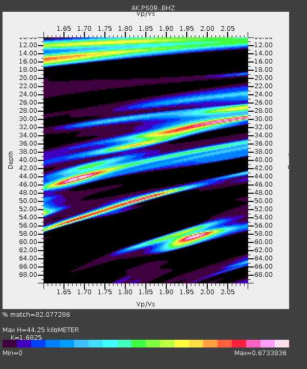
| Estimated Moho Depth: |
44.25 km |
| Estimated Crust Vp/Vs: |
1.68 |
| Assumed Crust Vp: |
6.566 km/s |
| Estimated Crust Vs: |
3.903 km/s |
| Estimated Crust Poisson's Ratio: |
0.23 |
|
| Radial Match: |
82.077286 % |
| Radial Bump: |
384 |
| Transverse Match: |
68.997955 % |
| Transverse Bump: |
400 |
| SOD ConfigId: |
25028951 |
| Insert Time: |
2021-06-04 22:15:36.454 +0000 |
| GWidth: |
2.5 |
| Max Bumps: |
400 |
| Tol: |
0.001 |
|

Signal To Noise
| Channel | StoN | STA | LTA |
| AK:PS09: :BHZ:20210521T22:25:16.868014Z | 3.3679442 | 1.6435044E-6 | 4.879845E-7 |
| AK:PS09: :BHN:20210521T22:25:16.868014Z | 0.84039384 | 3.9356243E-7 | 4.6830712E-7 |
| AK:PS09: :BHE:20210521T22:25:16.868014Z | 0.6411956 | 5.311841E-7 | 8.2842763E-7 |
| Arrivals |
| Ps | 4.7 SECOND |
| PpPs | 18 SECOND |
| PsPs/PpSs | 22 SECOND |


