You are here: Home > Network List > CC - Cascade Chain Volcano Monitoring Stations List
> Station SVIC Surveyor's Cave, OR, USA > Earthquake Result Viewer
SVIC Surveyor's Cave, OR, USA - Earthquake Result Viewer
| Earthquake location: |
Fiji Islands Region |
| Earthquake latitude/longitude: |
-16.6/-177.4 |
| Earthquake time(UTC): |
2021/05/21 (141) 22:13:18 GMT |
| Earthquake Depth: |
10 km |
| Earthquake Magnitude: |
6.5 mww |
| Earthquake Catalog/Contributor: |
NEIC PDE/us |
|
| Network: |
CC Cascade Chain Volcano Monitoring |
| Station: |
SVIC Surveyor's Cave, OR, USA |
| Lat/Lon: |
43.64 N/121.25 W |
| Elevation: |
1765 m |
|
| Distance: |
78.9 deg |
| Az: |
37.895 deg |
| Baz: |
234.218 deg |
| Ray Param: |
0.049340595 |
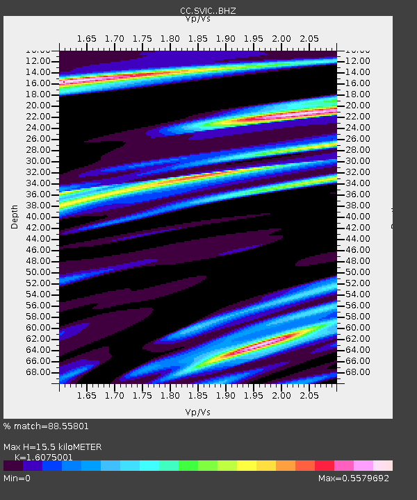
| Estimated Moho Depth: |
15.5 km |
| Estimated Crust Vp/Vs: |
1.61 |
| Assumed Crust Vp: |
6.597 km/s |
| Estimated Crust Vs: |
4.104 km/s |
| Estimated Crust Poisson's Ratio: |
0.18 |
|
| Radial Match: |
88.55801 % |
| Radial Bump: |
400 |
| Transverse Match: |
69.441475 % |
| Transverse Bump: |
400 |
| SOD ConfigId: |
25028951 |
| Insert Time: |
2021-06-04 22:20:52.324 +0000 |
| GWidth: |
2.5 |
| Max Bumps: |
400 |
| Tol: |
0.001 |
|

Signal To Noise
| Channel | StoN | STA | LTA |
| CC:SVIC: :BHZ:20210521T22:24:50.360018Z | 5.0188007 | 7.0529666E-7 | 1.405309E-7 |
| CC:SVIC: :BHN:20210521T22:24:50.360018Z | 0.82995987 | 2.047345E-7 | 2.4668E-7 |
| CC:SVIC: :BHE:20210521T22:24:50.360018Z | 1.5726798 | 2.9089105E-7 | 1.8496522E-7 |
| Arrivals |
| Ps | 1.5 SECOND |
| PpPs | 5.9 SECOND |
| PsPs/PpSs | 7.4 SECOND |


