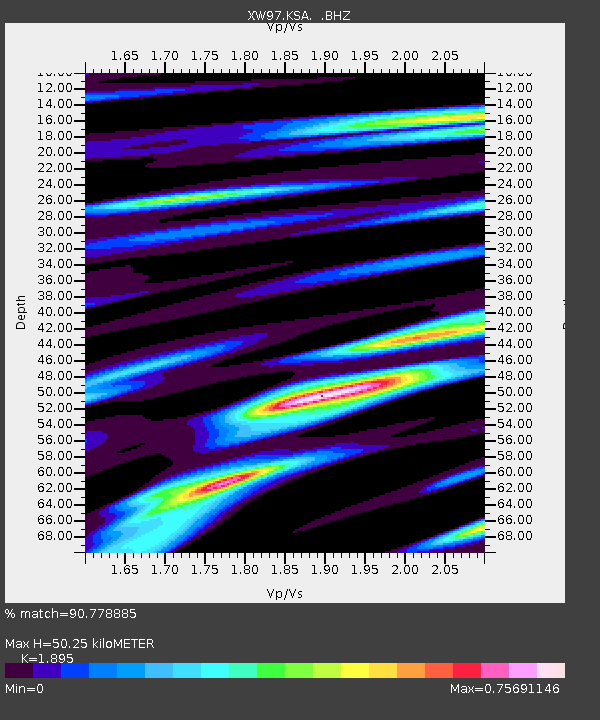
KSA XW.KSA - Earthquake Result Viewer

Earthquake location: Rat Islands, Aleutian Islands
Earthquake latitude/longitude: 51.6/175.2
Earthquake time(UTC): 1998/08/20 (232) 15:00:08 GMT
Earthquake Depth: 33 km
Earthquake Magnitude: 5.6 MB, 6.0 MS, 6.2 UNKNOWN, 6.2 MW
Earthquake Catalog/Contributor: WHDF/NEIC
Network: XW Tien Shan Continental Dynamics
Station: KSA XW.KSA
Lat/Lon: 41.54 N/77.93 E
Elevation: 3398 m
Distance: 62.8 deg
Az: 303.173 deg
Baz: 44.042 deg
Ray Param: 0.059928015
Estimated Moho Depth: 50.25 km
Estimated Crust Vp/Vs: 1.89
Assumed Crust Vp: 6.491 km/s
Estimated Crust Vs: 3.425 km/s
Estimated Crust Poisson's Ratio: 0.31
Radial Match: 90.778885 %
Radial Bump: 400
Transverse Match: 81.90837 %
Transverse Bump: 400
SOD ConfigId: 4480
Insert Time: 2010-02-26 15:37:14.141 +0000
GWidth: 2.5
Max Bumps: 400
Tol: 0.001

Signal To Noise

ChannelStoNSTALTA
XW:KSA: :BHZ:19980820T15:09:59.649011Z16.091611.4753028E-69.1681486E-8
XW:KSA: :BHN:19980820T15:09:59.649011Z8.7036444.367653E-75.018189E-8
XW:KSA: :BHE:19980820T15:09:59.649011Z2.71707734.1596914E-71.5309433E-7
Arrivals
Ps7.2 SECOND
PpPs21 SECOND
PsPs/PpSs29 SECOND