You are here: Home > Network List > TX - Texas Seismological Network Stations List
> Station WTFS Witchita Falls > Earthquake Result Viewer
WTFS Witchita Falls - Earthquake Result Viewer
| Earthquake location: |
Near Coast Of Ecuador |
| Earthquake latitude/longitude: |
-0.5/-80.3 |
| Earthquake time(UTC): |
2017/12/03 (337) 11:19:06 GMT |
| Earthquake Depth: |
25 km |
| Earthquake Magnitude: |
6.0 Mww |
| Earthquake Catalog/Contributor: |
NEIC PDE/us |
|
| Network: |
TX Texas Seismological Network |
| Station: |
WTFS Witchita Falls |
| Lat/Lon: |
33.77 N/98.46 W |
| Elevation: |
277 m |
|
| Distance: |
38.1 deg |
| Az: |
335.095 deg |
| Baz: |
149.635 deg |
| Ray Param: |
0.07570831 |
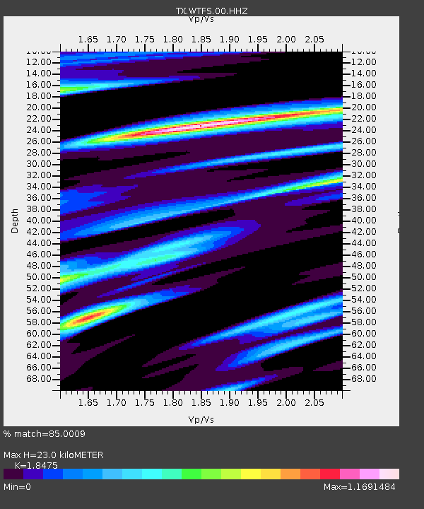
| Estimated Moho Depth: |
23.0 km |
| Estimated Crust Vp/Vs: |
1.85 |
| Assumed Crust Vp: |
6.426 km/s |
| Estimated Crust Vs: |
3.478 km/s |
| Estimated Crust Poisson's Ratio: |
0.29 |
|
| Radial Match: |
85.0009 % |
| Radial Bump: |
293 |
| Transverse Match: |
61.125053 % |
| Transverse Bump: |
369 |
| SOD ConfigId: |
2429771 |
| Insert Time: |
2017-12-17 11:27:04.587 +0000 |
| GWidth: |
2.5 |
| Max Bumps: |
400 |
| Tol: |
0.001 |
|

Signal To Noise
| Channel | StoN | STA | LTA |
| TX:WTFS:00:HHZ:20171203T11:25:53.035006Z | 5.3513513 | 3.8840219E-7 | 7.2580214E-8 |
| TX:WTFS:00:HH1:20171203T11:25:53.035006Z | 1.5565519 | 1.7041792E-7 | 1.0948424E-7 |
| TX:WTFS:00:HH2:20171203T11:25:53.035006Z | 1.000385 | 1.313657E-7 | 1.3131513E-7 |
| Arrivals |
| Ps | 3.3 SECOND |
| PpPs | 9.5 SECOND |
| PsPs/PpSs | 13 SECOND |


