You are here: Home > Network List > CN - Canadian National Seismograph Network Stations List
> Station PHC Port Hardy, BC, CA > Earthquake Result Viewer
PHC Port Hardy, BC, CA - Earthquake Result Viewer
| Earthquake location: |
Fiji Islands Region |
| Earthquake latitude/longitude: |
-16.6/-177.4 |
| Earthquake time(UTC): |
2021/05/21 (141) 22:13:18 GMT |
| Earthquake Depth: |
10 km |
| Earthquake Magnitude: |
6.5 mww |
| Earthquake Catalog/Contributor: |
NEIC PDE/us |
|
| Network: |
CN Canadian National Seismograph Network |
| Station: |
PHC Port Hardy, BC, CA |
| Lat/Lon: |
50.71 N/127.43 W |
| Elevation: |
32 m |
|
| Distance: |
80.0 deg |
| Az: |
29.612 deg |
| Baz: |
228.17 deg |
| Ray Param: |
0.048566207 |
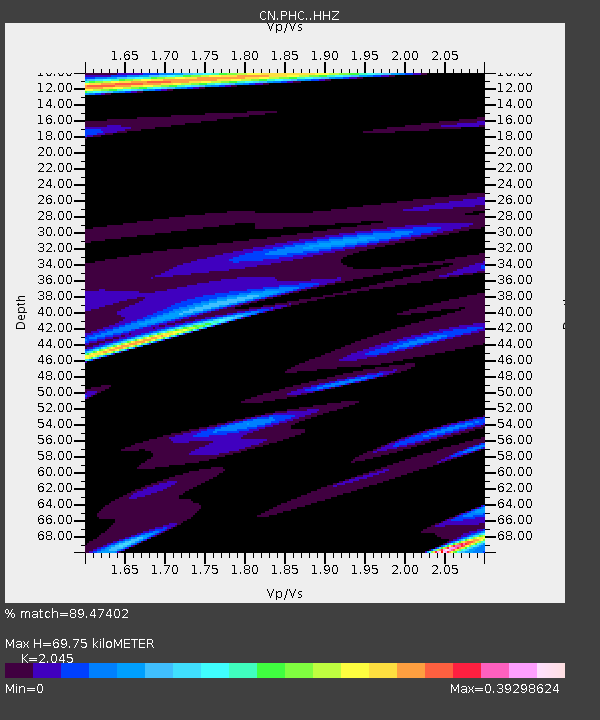
| Estimated Moho Depth: |
69.75 km |
| Estimated Crust Vp/Vs: |
2.05 |
| Assumed Crust Vp: |
6.545 km/s |
| Estimated Crust Vs: |
3.201 km/s |
| Estimated Crust Poisson's Ratio: |
0.34 |
|
| Radial Match: |
89.47402 % |
| Radial Bump: |
400 |
| Transverse Match: |
80.932144 % |
| Transverse Bump: |
400 |
| SOD ConfigId: |
25028951 |
| Insert Time: |
2021-06-04 22:23:05.880 +0000 |
| GWidth: |
2.5 |
| Max Bumps: |
400 |
| Tol: |
0.001 |
|

Signal To Noise
| Channel | StoN | STA | LTA |
| CN:PHC: :HHZ:20210521T22:24:56.530001Z | 3.6823254 | 6.3552187E-7 | 1.7258712E-7 |
| CN:PHC: :HHN:20210521T22:24:56.530001Z | 1.504551 | 1.5831208E-7 | 1.05222135E-7 |
| CN:PHC: :HHE:20210521T22:24:56.530001Z | 1.627391 | 1.837532E-7 | 1.1291276E-7 |
| Arrivals |
| Ps | 11 SECOND |
| PpPs | 32 SECOND |
| PsPs/PpSs | 43 SECOND |


