You are here: Home > Network List > GS - US Geological Survey Networks Stations List
> Station MCA04 MCA04, Monte Cristo Range, NV > Earthquake Result Viewer
MCA04 MCA04, Monte Cristo Range, NV - Earthquake Result Viewer
| Earthquake location: |
Fiji Islands Region |
| Earthquake latitude/longitude: |
-16.6/-177.4 |
| Earthquake time(UTC): |
2021/05/21 (141) 22:13:18 GMT |
| Earthquake Depth: |
10 km |
| Earthquake Magnitude: |
6.5 mww |
| Earthquake Catalog/Contributor: |
NEIC PDE/us |
|
| Network: |
GS US Geological Survey Networks |
| Station: |
MCA04 MCA04, Monte Cristo Range, NV |
| Lat/Lon: |
38.08 N/117.71 W |
| Elevation: |
1662 m |
|
| Distance: |
78.0 deg |
| Az: |
44.134 deg |
| Baz: |
237.782 deg |
| Ray Param: |
0.04994671 |
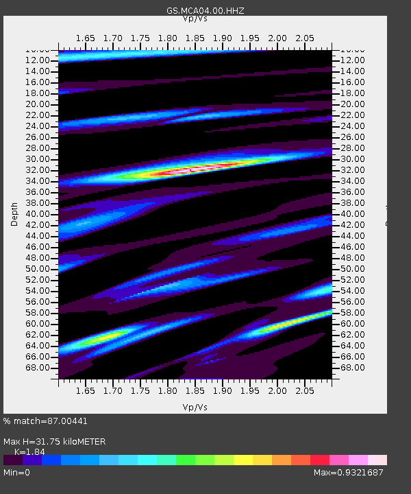
| Estimated Moho Depth: |
31.75 km |
| Estimated Crust Vp/Vs: |
1.84 |
| Assumed Crust Vp: |
6.276 km/s |
| Estimated Crust Vs: |
3.411 km/s |
| Estimated Crust Poisson's Ratio: |
0.29 |
|
| Radial Match: |
87.00441 % |
| Radial Bump: |
400 |
| Transverse Match: |
82.1971 % |
| Transverse Bump: |
400 |
| SOD ConfigId: |
25028951 |
| Insert Time: |
2021-06-04 22:24:22.119 +0000 |
| GWidth: |
2.5 |
| Max Bumps: |
400 |
| Tol: |
0.001 |
|

Signal To Noise
| Channel | StoN | STA | LTA |
| GS:MCA04:00:HHZ:20210521T22:24:45.504977Z | 2.3891487 | 4.5375089E-7 | 1.8992158E-7 |
| GS:MCA04:00:HH1:20210521T22:24:45.504977Z | 1.0492591 | 2.8504456E-7 | 2.716627E-7 |
| GS:MCA04:00:HH2:20210521T22:24:45.504977Z | 0.582725 | 1.4962612E-7 | 2.567697E-7 |
| Arrivals |
| Ps | 4.4 SECOND |
| PpPs | 14 SECOND |
| PsPs/PpSs | 18 SECOND |


