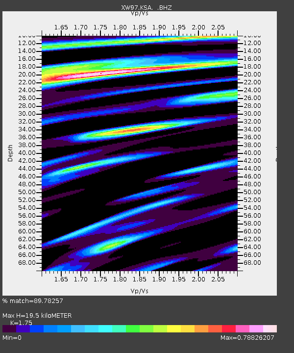
KSA XW.KSA - Earthquake Result Viewer
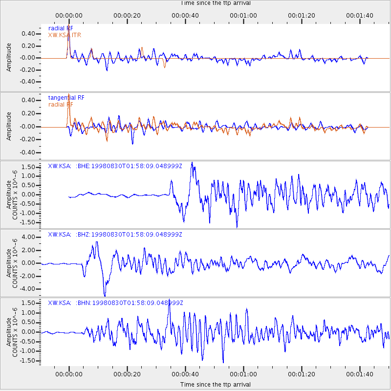
Earthquake location: Mariana Islands Region
Earthquake latitude/longitude: 17.1/148.1
Earthquake time(UTC): 1998/08/30 (242) 01:48:08 GMT
Earthquake Depth: 33 km
Earthquake Magnitude: 6.0 MB, 6.1 MS, 6.2 UNKNOWN, 5.9 ME
Earthquake Catalog/Contributor: WHDF/NEIC
Network: XW Tien Shan Continental Dynamics
Station: KSA XW.KSA
Lat/Lon: 41.54 N/77.93 E
Elevation: 3398 m
Distance: 64.1 deg
Az: 308.29 deg
Baz: 89.661 deg
Ray Param: 0.059057627
Estimated Moho Depth: 19.5 km
Estimated Crust Vp/Vs: 1.75
Assumed Crust Vp: 6.491 km/s
Estimated Crust Vs: 3.709 km/s
Estimated Crust Poisson's Ratio: 0.26
Radial Match: 89.78257 %
Radial Bump: 400
Transverse Match: 83.63406 %
Transverse Bump: 400
SOD ConfigId: 4480
Insert Time: 2010-02-26 15:37:17.887 +0000
GWidth: 2.5
Max Bumps: 400
Tol: 0.001

Signal To Noise

ChannelStoNSTALTA
XW:KSA: :BHZ:19980830T01:58:09.048999Z2.94540171.9643882E-76.669339E-8
XW:KSA: :BHN:19980830T01:58:09.048999Z0.602100732.5064532E-84.1628468E-8
XW:KSA: :BHE:19980830T01:58:09.048999Z0.966340966.978312E-87.2213766E-8
Arrivals
Ps2.4 SECOND
PpPs7.9 SECOND
PsPs/PpSs10 SECOND