You are here: Home > Network List > UW - Pacific Northwest Regional Seismic Network Stations List
> Station BERY Pilchuck Tree Farm, Arlington, WA, USA > Earthquake Result Viewer
BERY Pilchuck Tree Farm, Arlington, WA, USA - Earthquake Result Viewer
| Earthquake location: |
Fiji Islands Region |
| Earthquake latitude/longitude: |
-16.6/-177.4 |
| Earthquake time(UTC): |
2021/05/21 (141) 22:13:18 GMT |
| Earthquake Depth: |
10 km |
| Earthquake Magnitude: |
6.5 mww |
| Earthquake Catalog/Contributor: |
NEIC PDE/us |
|
| Network: |
UW Pacific Northwest Regional Seismic Network |
| Station: |
BERY Pilchuck Tree Farm, Arlington, WA, USA |
| Lat/Lon: |
48.26 N/122.10 W |
| Elevation: |
150 m |
|
| Distance: |
81.2 deg |
| Az: |
33.765 deg |
| Baz: |
232.897 deg |
| Ray Param: |
0.04778822 |
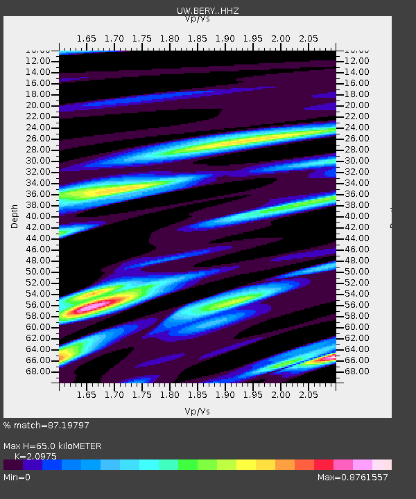
| Estimated Moho Depth: |
65.0 km |
| Estimated Crust Vp/Vs: |
2.10 |
| Assumed Crust Vp: |
6.566 km/s |
| Estimated Crust Vs: |
3.13 km/s |
| Estimated Crust Poisson's Ratio: |
0.35 |
|
| Radial Match: |
87.19797 % |
| Radial Bump: |
400 |
| Transverse Match: |
77.75415 % |
| Transverse Bump: |
400 |
| SOD ConfigId: |
25028951 |
| Insert Time: |
2021-06-04 22:33:56.645 +0000 |
| GWidth: |
2.5 |
| Max Bumps: |
400 |
| Tol: |
0.001 |
|

Signal To Noise
| Channel | StoN | STA | LTA |
| UW:BERY: :HHZ:20210521T22:25:02.589999Z | 3.86589 | 5.876064E-7 | 1.5199771E-7 |
| UW:BERY: :HHN:20210521T22:25:02.589999Z | 1.8361393 | 2.0885003E-7 | 1.137441E-7 |
| UW:BERY: :HHE:20210521T22:25:02.589999Z | 0.99877614 | 1.7040223E-7 | 1.7061103E-7 |
| Arrivals |
| Ps | 11 SECOND |
| PpPs | 30 SECOND |
| PsPs/PpSs | 41 SECOND |


