You are here: Home > Network List > UW - Pacific Northwest Regional Seismic Network Stations List
> Station HILL La Conner, WA, USA > Earthquake Result Viewer
HILL La Conner, WA, USA - Earthquake Result Viewer
| Earthquake location: |
Fiji Islands Region |
| Earthquake latitude/longitude: |
-16.6/-177.4 |
| Earthquake time(UTC): |
2021/05/21 (141) 22:13:18 GMT |
| Earthquake Depth: |
10 km |
| Earthquake Magnitude: |
6.5 mww |
| Earthquake Catalog/Contributor: |
NEIC PDE/us |
|
| Network: |
UW Pacific Northwest Regional Seismic Network |
| Station: |
HILL La Conner, WA, USA |
| Lat/Lon: |
48.39 N/122.45 W |
| Elevation: |
38 m |
|
| Distance: |
81.0 deg |
| Az: |
33.522 deg |
| Baz: |
232.598 deg |
| Ray Param: |
0.04786461 |
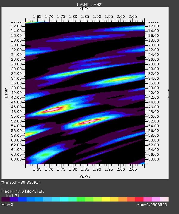
| Estimated Moho Depth: |
47.0 km |
| Estimated Crust Vp/Vs: |
1.71 |
| Assumed Crust Vp: |
6.566 km/s |
| Estimated Crust Vs: |
3.84 km/s |
| Estimated Crust Poisson's Ratio: |
0.24 |
|
| Radial Match: |
89.336914 % |
| Radial Bump: |
400 |
| Transverse Match: |
83.097015 % |
| Transverse Bump: |
400 |
| SOD ConfigId: |
25028951 |
| Insert Time: |
2021-06-04 22:34:27.375 +0000 |
| GWidth: |
2.5 |
| Max Bumps: |
400 |
| Tol: |
0.001 |
|

Signal To Noise
| Channel | StoN | STA | LTA |
| UW:HILL: :HHZ:20210521T22:25:01.999972Z | 2.1441991 | 7.90427E-7 | 3.6863506E-7 |
| UW:HILL: :HHN:20210521T22:25:01.999972Z | 1.3675596 | 4.1169682E-7 | 3.010449E-7 |
| UW:HILL: :HHE:20210521T22:25:01.999972Z | 1.26404 | 3.7105218E-7 | 2.9354467E-7 |
| Arrivals |
| Ps | 5.2 SECOND |
| PpPs | 19 SECOND |
| PsPs/PpSs | 24 SECOND |


