You are here: Home > Network List > UW - Pacific Northwest Regional Seismic Network Stations List
> Station IRON Crane, OR, USA > Earthquake Result Viewer
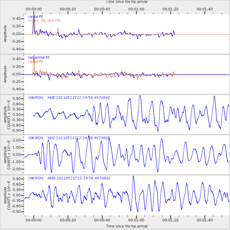
IRON Crane, OR, USA - Earthquake Result Viewer
| Earthquake location: |
Fiji Islands Region |
| Earthquake latitude/longitude: |
-16.6/-177.4 |
| Earthquake time(UTC): |
2021/05/21 (141) 22:13:18 GMT |
| Earthquake Depth: |
10 km |
| Earthquake Magnitude: |
6.5 mww |
| Earthquake Catalog/Contributor: |
NEIC PDE/us |
|
| Network: |
UW Pacific Northwest Regional Seismic Network |
| Station: |
IRON Crane, OR, USA |
| Lat/Lon: |
43.36 N/118.47 W |
| Elevation: |
1226 m |
|
| Distance: |
80.4 deg |
| Az: |
39.303 deg |
| Baz: |
236.377 deg |
| Ray Param: |
0.04831538 |
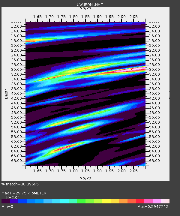
| Estimated Moho Depth: |
29.75 km |
| Estimated Crust Vp/Vs: |
2.04 |
| Assumed Crust Vp: |
6.279 km/s |
| Estimated Crust Vs: |
3.078 km/s |
| Estimated Crust Poisson's Ratio: |
0.34 |
|
| Radial Match: |
88.89695 % |
| Radial Bump: |
369 |
| Transverse Match: |
77.66209 % |
| Transverse Bump: |
393 |
| SOD ConfigId: |
25028951 |
| Insert Time: |
2021-06-04 22:34:30.179 +0000 |
| GWidth: |
2.5 |
| Max Bumps: |
400 |
| Tol: |
0.001 |
|
Signal To Noise
| Channel | StoN | STA | LTA |
| UW:IRON: :HHZ:20210521T22:24:58.467989Z | 3.3649306 | 4.6451288E-7 | 1.380453E-7 |
| UW:IRON: :HHN:20210521T22:24:58.467989Z | 0.80716497 | 1.0223277E-7 | 1.266566E-7 |
| UW:IRON: :HHE:20210521T22:24:58.467989Z | 1.3023574 | 1.7628852E-7 | 1.353611E-7 |
| Arrivals |
| Ps | 5.0 SECOND |
| PpPs | 14 SECOND |
| PsPs/PpSs | 19 SECOND |


