You are here: Home > Network List > UW - Pacific Northwest Regional Seismic Network Stations List
> Station SSO2 House Mountain, Oregon, USA > Earthquake Result Viewer
SSO2 House Mountain, Oregon, USA - Earthquake Result Viewer
| Earthquake location: |
Fiji Islands Region |
| Earthquake latitude/longitude: |
-16.6/-177.4 |
| Earthquake time(UTC): |
2021/05/21 (141) 22:13:18 GMT |
| Earthquake Depth: |
10 km |
| Earthquake Magnitude: |
6.5 mww |
| Earthquake Catalog/Contributor: |
NEIC PDE/us |
|
| Network: |
UW Pacific Northwest Regional Seismic Network |
| Station: |
SSO2 House Mountain, Oregon, USA |
| Lat/Lon: |
44.84 N/122.48 W |
| Elevation: |
1202 m |
|
| Distance: |
78.9 deg |
| Az: |
36.378 deg |
| Baz: |
233.07 deg |
| Ray Param: |
0.049341973 |
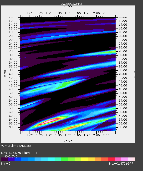
| Estimated Moho Depth: |
64.75 km |
| Estimated Crust Vp/Vs: |
1.75 |
| Assumed Crust Vp: |
6.566 km/s |
| Estimated Crust Vs: |
3.763 km/s |
| Estimated Crust Poisson's Ratio: |
0.26 |
|
| Radial Match: |
84.63188 % |
| Radial Bump: |
400 |
| Transverse Match: |
64.00306 % |
| Transverse Bump: |
400 |
| SOD ConfigId: |
25028951 |
| Insert Time: |
2021-06-04 22:35:16.121 +0000 |
| GWidth: |
2.5 |
| Max Bumps: |
400 |
| Tol: |
0.001 |
|

Signal To Noise
| Channel | StoN | STA | LTA |
| UW:SSO2: :HHZ:20210521T22:24:50.339999Z | 1.8714114 | 5.320685E-7 | 2.84314E-7 |
| UW:SSO2: :HHN:20210521T22:24:50.339999Z | 1.8841362 | 6.2481956E-7 | 3.3162124E-7 |
| UW:SSO2: :HHE:20210521T22:24:50.339999Z | 0.86598414 | 3.38797E-7 | 3.9122776E-7 |
| Arrivals |
| Ps | 7.6 SECOND |
| PpPs | 26 SECOND |
| PsPs/PpSs | 34 SECOND |


