You are here: Home > Network List > CI - Caltech Regional Seismic Network Stations List
> Station LRL Laurel Mtn Radio Fac, Ridgecrest, CA, USA > Earthquake Result Viewer
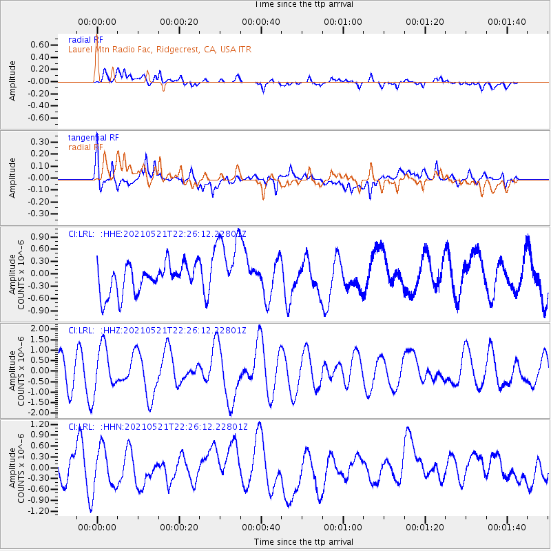
LRL Laurel Mtn Radio Fac, Ridgecrest, CA, USA - Earthquake Result Viewer
*The percent match for this event was below the threshold and hence no stack was calculated.
| Earthquake location: |
Near Coast Of Nicaragua |
| Earthquake latitude/longitude: |
12.5/-87.7 |
| Earthquake time(UTC): |
2021/05/21 (141) 22:19:51 GMT |
| Earthquake Depth: |
56 km |
| Earthquake Magnitude: |
5.5 Mwr |
| Earthquake Catalog/Contributor: |
NEIC PDE/us |
|
| Network: |
CI Caltech Regional Seismic Network |
| Station: |
LRL Laurel Mtn Radio Fac, Ridgecrest, CA, USA |
| Lat/Lon: |
35.48 N/117.68 W |
| Elevation: |
1340 m |
|
| Distance: |
35.5 deg |
| Az: |
315.336 deg |
| Baz: |
122.725 deg |
| Ray Param: |
$rayparam |
*The percent match for this event was below the threshold and hence was not used in the summary stack. |
|
| Radial Match: |
55.77789 % |
| Radial Bump: |
400 |
| Transverse Match: |
58.573193 % |
| Transverse Bump: |
400 |
| SOD ConfigId: |
25028951 |
| Insert Time: |
2021-06-04 22:41:14.408 +0000 |
| GWidth: |
2.5 |
| Max Bumps: |
400 |
| Tol: |
0.001 |
|
Signal To Noise
| Channel | StoN | STA | LTA |
| CI:LRL: :HHZ:20210521T22:26:12.22801Z | 0.98168206 | 1.0409993E-6 | 1.0604242E-6 |
| CI:LRL: :HHN:20210521T22:26:12.22801Z | 1.401847 | 5.342083E-7 | 3.810746E-7 |
| CI:LRL: :HHE:20210521T22:26:12.22801Z | 2.2345731 | 7.9859683E-7 | 3.5738225E-7 |
| Arrivals |
| Ps | |
| PpPs | |
| PsPs/PpSs | |


