You are here: Home > Network List > WY - Yellowstone Wyoming Seismic Network Stations List
> Station YHR Hawk's Rest, WY, USA > Earthquake Result Viewer
YHR Hawk's Rest, WY, USA - Earthquake Result Viewer
| Earthquake location: |
Northern Chile |
| Earthquake latitude/longitude: |
-19.8/-69.2 |
| Earthquake time(UTC): |
2017/11/17 (321) 16:45:46 GMT |
| Earthquake Depth: |
97 km |
| Earthquake Magnitude: |
5.0 Mww |
| Earthquake Catalog/Contributor: |
NEIC PDE/us |
|
| Network: |
WY Yellowstone Wyoming Seismic Network |
| Station: |
YHR Hawk's Rest, WY, USA |
| Lat/Lon: |
44.11 N/110.08 W |
| Elevation: |
2976 m |
|
| Distance: |
73.8 deg |
| Az: |
330.567 deg |
| Baz: |
140.042 deg |
| Ray Param: |
0.052518535 |
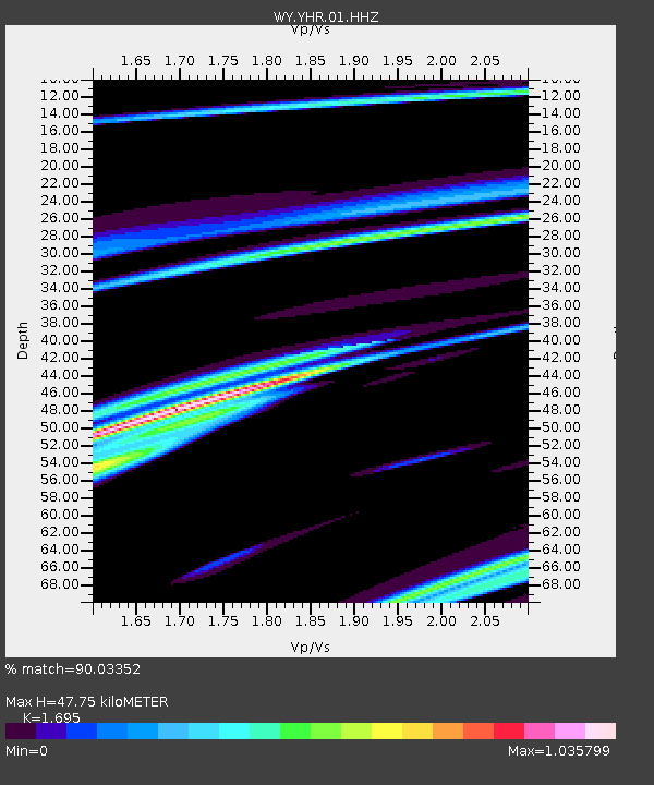
| Estimated Moho Depth: |
47.75 km |
| Estimated Crust Vp/Vs: |
1.70 |
| Assumed Crust Vp: |
6.35 km/s |
| Estimated Crust Vs: |
3.746 km/s |
| Estimated Crust Poisson's Ratio: |
0.23 |
|
| Radial Match: |
90.03352 % |
| Radial Bump: |
234 |
| Transverse Match: |
46.81538 % |
| Transverse Bump: |
400 |
| SOD ConfigId: |
2429771 |
| Insert Time: |
2017-12-17 17:01:32.951 +0000 |
| GWidth: |
2.5 |
| Max Bumps: |
400 |
| Tol: |
0.001 |
|
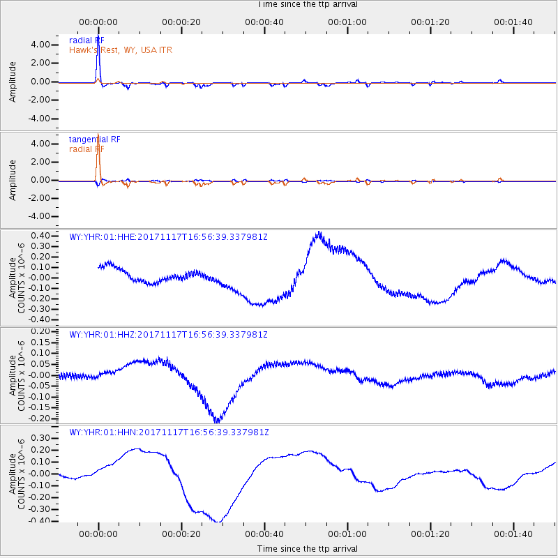
Signal To Noise
| Channel | StoN | STA | LTA |
| WY:YHR:01:HHZ:20171117T16:56:39.337981Z | 1.3945287 | 2.6764722E-8 | 1.9192665E-8 |
| WY:YHR:01:HHN:20171117T16:56:39.337981Z | 2.0225267 | 1.09615236E-7 | 5.4197173E-8 |
| WY:YHR:01:HHE:20171117T16:56:39.337981Z | 2.2822485 | 1.3547077E-7 | 5.9358467E-8 |
| Arrivals |
| Ps | 5.4 SECOND |
| PpPs | 20 SECOND |
| PsPs/PpSs | 25 SECOND |


