You are here: Home > Network List > KZ - Kazakhstan Network Stations List
> Station AKTK Aktyubinsk, Kazakstan > Earthquake Result Viewer
AKTK Aktyubinsk, Kazakstan - Earthquake Result Viewer
| Earthquake location: |
Lake Tanganyika Region |
| Earthquake latitude/longitude: |
-8.0/30.7 |
| Earthquake time(UTC): |
2000/10/02 (276) 02:25:31 GMT |
| Earthquake Depth: |
34 km |
| Earthquake Magnitude: |
6.1 MB, 6.7 MS, 6.5 MW, 6.2 ME |
| Earthquake Catalog/Contributor: |
WHDF/NEIC |
|
| Network: |
KZ Kazakhstan Network |
| Station: |
AKTK Aktyubinsk, Kazakstan |
| Lat/Lon: |
50.43 N/58.02 E |
| Elevation: |
360 m |
|
| Distance: |
62.8 deg |
| Az: |
19.257 deg |
| Baz: |
210.717 deg |
| Ray Param: |
0.059921753 |
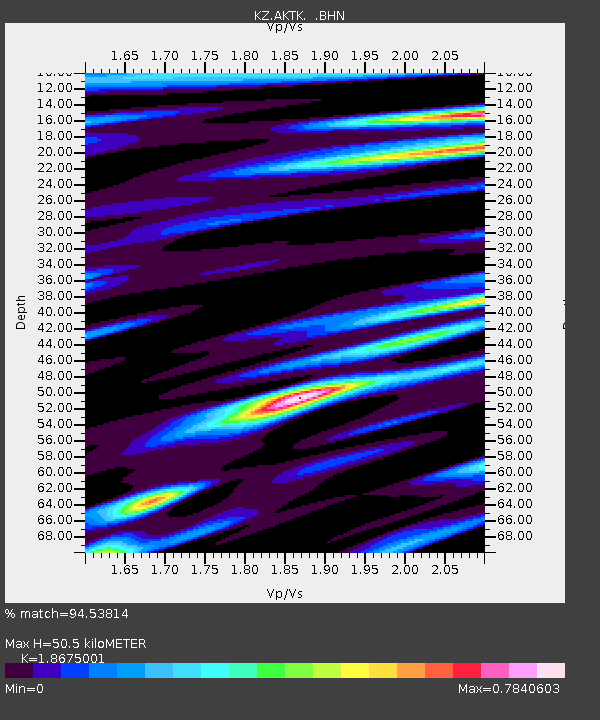
| Estimated Moho Depth: |
50.5 km |
| Estimated Crust Vp/Vs: |
1.87 |
| Assumed Crust Vp: |
6.353 km/s |
| Estimated Crust Vs: |
3.402 km/s |
| Estimated Crust Poisson's Ratio: |
0.30 |
|
| Radial Match: |
94.53814 % |
| Radial Bump: |
400 |
| Transverse Match: |
87.051254 % |
| Transverse Bump: |
400 |
| SOD ConfigId: |
3744 |
| Insert Time: |
2010-03-09 08:41:46.970 +0000 |
| GWidth: |
2.5 |
| Max Bumps: |
400 |
| Tol: |
0.001 |
|

Signal To Noise
| Channel | StoN | STA | LTA |
| KZ:AKTK: :BHN:20001002T02:35:22.768008Z | 8.248246 | 5.208829E-7 | 6.315074E-8 |
| KZ:AKTK: :BHE:20001002T02:35:22.768008Z | 3.3904903 | 2.1280744E-7 | 6.276598E-8 |
| KZ:AKTK: :BHZ:20001002T02:35:22.768008Z | 16.80725 | 1.3206743E-6 | 7.8577656E-8 |
| Arrivals |
| Ps | 7.2 SECOND |
| PpPs | 22 SECOND |
| PsPs/PpSs | 29 SECOND |


