You are here: Home > Network List > CI - Caltech Regional Seismic Network Stations List
> Station SMM Simmler, CA, USA > Earthquake Result Viewer
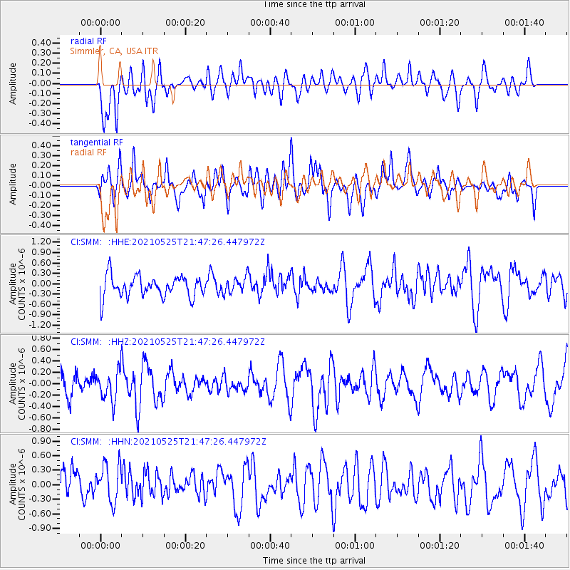
SMM Simmler, CA, USA - Earthquake Result Viewer
*The percent match for this event was below the threshold and hence no stack was calculated.
| Earthquake location: |
Tonga Islands |
| Earthquake latitude/longitude: |
-17.6/-174.8 |
| Earthquake time(UTC): |
2021/05/25 (145) 21:36:44 GMT |
| Earthquake Depth: |
200 km |
| Earthquake Magnitude: |
5.7 mww |
| Earthquake Catalog/Contributor: |
NEIC PDE/us |
|
| Network: |
CI Caltech Regional Seismic Network |
| Station: |
SMM Simmler, CA, USA |
| Lat/Lon: |
35.31 N/120.00 W |
| Elevation: |
599 m |
|
| Distance: |
73.9 deg |
| Az: |
44.075 deg |
| Baz: |
234.227 deg |
| Ray Param: |
$rayparam |
*The percent match for this event was below the threshold and hence was not used in the summary stack. |
|
| Radial Match: |
35.521877 % |
| Radial Bump: |
400 |
| Transverse Match: |
63.492035 % |
| Transverse Bump: |
400 |
| SOD ConfigId: |
25028951 |
| Insert Time: |
2021-06-08 21:45:56.585 +0000 |
| GWidth: |
2.5 |
| Max Bumps: |
400 |
| Tol: |
0.001 |
|
Signal To Noise
| Channel | StoN | STA | LTA |
| CI:SMM: :HHZ:20210525T21:47:26.447972Z | 1.2470636 | 2.671686E-7 | 2.1423813E-7 |
| CI:SMM: :HHN:20210525T21:47:26.447972Z | 1.1623504 | 4.135016E-7 | 3.5574607E-7 |
| CI:SMM: :HHE:20210525T21:47:26.447972Z | 0.8109548 | 2.4500156E-7 | 3.0211493E-7 |
| Arrivals |
| Ps | |
| PpPs | |
| PsPs/PpSs | |


