You are here: Home > Network List > XW97 - Tien Shan Continental Dynamics Stations List
> Station KSA XW.KSA > Earthquake Result Viewer
KSA XW.KSA - Earthquake Result Viewer
| Earthquake location: |
Minahassa Peninsula, Sulawesi |
| Earthquake latitude/longitude: |
0.2/119.5 |
| Earthquake time(UTC): |
1999/02/23 (054) 07:27:56 GMT |
| Earthquake Depth: |
33 km |
| Earthquake Magnitude: |
5.6 MB, 5.8 MS |
| Earthquake Catalog/Contributor: |
WHDF/NEIC |
|
| Network: |
XW Tien Shan Continental Dynamics |
| Station: |
KSA XW.KSA |
| Lat/Lon: |
41.54 N/77.93 E |
| Elevation: |
3398 m |
|
| Distance: |
55.7 deg |
| Az: |
322.881 deg |
| Baz: |
126.495 deg |
| Ray Param: |
0.06456228 |
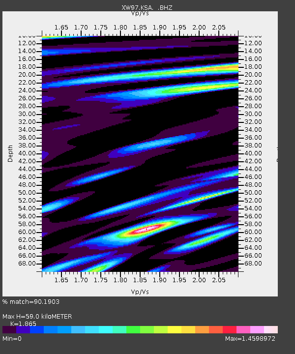
| Estimated Moho Depth: |
59.0 km |
| Estimated Crust Vp/Vs: |
1.87 |
| Assumed Crust Vp: |
6.491 km/s |
| Estimated Crust Vs: |
3.48 km/s |
| Estimated Crust Poisson's Ratio: |
0.30 |
|
| Radial Match: |
90.1903 % |
| Radial Bump: |
400 |
| Transverse Match: |
86.35538 % |
| Transverse Bump: |
400 |
| SOD ConfigId: |
4480 |
| Insert Time: |
2010-02-26 15:37:38.306 +0000 |
| GWidth: |
2.5 |
| Max Bumps: |
400 |
| Tol: |
0.001 |
|

Signal To Noise
| Channel | StoN | STA | LTA |
| XW:KSA: :BHZ:19990223T07:36:58.942024Z | 4.5023165 | 3.698559E-7 | 8.214791E-8 |
| XW:KSA: :BHN:19990223T07:36:58.942024Z | 2.413607 | 1.18524724E-7 | 4.910689E-8 |
| XW:KSA: :BHE:19990223T07:36:58.942024Z | 3.2536087 | 2.1303197E-7 | 6.54756E-8 |
| Arrivals |
| Ps | 8.3 SECOND |
| PpPs | 25 SECOND |
| PsPs/PpSs | 33 SECOND |


